Lucky Valley district, south-east of Warwick, Queensland · Gold; potential copper
Exploration · target definition
Why we selected it: Historical surface gold results and an interpreted intrusive corridor provide specific targets for mapping, sampling and geological assessment.
Historical gold workings and assays up to 14.3 g/t Au identify targets along an interpreted 11 km intrusive corridor. Lucky Valley provides a separate opportunity to test the source, continuity and scale of gold mineralisation.
A separate MineFinder project assessment, with commercial options to be developed alongside target definition.
HISTORICAL MINING AND EXPLORATION
A goldfield history reaching back to 1851
Lucky Valley’s history records gold in quartz, a nineteenth-century alluvial rush and repeated attempts to find and work the reefs above the gullies. The archived account describes a small hill carrying gold-bearing quartz at the head of the workings. That relationship gives the modern search for the alluvial source a specific historical lead.
1851Early gold-bearing quartz
The historical account records quartz sent by John McArthur to the Reverend W. B. Clarke for examination.
1868Payable alluvial gold reported
A June newspaper account describes a gold discovery near the Elbow and claims taken up in a gully between prominent spurs.
1869Goldfield gazettal recorded
The archived history dates the gazettal to 12 March and describes mining along Lucky Valley and adjoining gullies.
Historical source: Lucky Valley Gold & Mineral Field, retained in the project archive as Lucky Valley Gold.pdf (2015), checked against the accompanying scanned book pages 37–39. Dates and early newspaper accounts below are attributed to that compilation.
Early discoveries at Lord John’s Swamp
The archive traces the district’s early gold discoveries to August 1851, when John McArthur sent quartz to the Reverend W. B. Clarke. It reproduces Clarke’s later account of recovering gold from that material. This is an early record of gold-bearing rock in the locality, preceding the better-known alluvial rush.
The account also records an August 1856 visit by N. Bartley, who purchased 12.4 grams of alluvial gold from a shepherd said to have found it at Lord John’s Swamp. Together, the quartz and alluvial accounts establish the two strands that recur throughout Lucky Valley’s history: gold in the surrounding rock and gold concentrated in the drainage system.
The 1868 discovery and the 1869 goldfield
A Warwick Argus report dated 6 June 1868, reproduced in the archive, describes a man named Williams bringing gold into Warwick and seeking protection for a prospecting claim. He reportedly recovered about 5 ounces 2 pennyweights from three loads of dirt. The news attracted residents and prospectors to the locality, and C. F. Cumming was appointed Acting Gold Commissioner to issue miners’ rights and mark claims.
The discovery was described as being on Canning Downs, near the Elbow, in a gully between two prominent spurs. The historical compilation records that the field was gazetted on 12 March 1869. These descriptions place the workings in a recognisable landscape of ridges and short gullies draining towards the Condamine River.
The worked gullies and the hill above them
The most useful part of the history for present exploration is its description of the terrain. It places the main diggings near the Condamine’s Elbow and describes workings around a small hill and two drainage systems. Elbow Gully, the easternmost, was reportedly worked for at least 300 metres, beginning about 1.6 km from its junction with the river.
The other drainage had three branches. Its middle branch, Lucky Valley, was described as an early and possibly richer part of the field, with about 400 metres worked in 1869, starting approximately 3.2 km upstream from the river. At the head of that valley, the account describes metasedimentary rock containing quartz leaders with visible gold and a shaft sunk to investigate them.
Duffer Gully carried a shorter worked strip at the head of the eastern branch, while Frenchman’s Gully occupied a small gully on the side of the intervening ridge. Limekiln Gully, farther north in the Lord John’s Swamp area, also yielded alluvial gold. The compilation gives no complete production totals for these workings, so the mapped distribution and geological descriptions provide the more useful exploration record.
Repeated attempts to follow the gold into bedrock
The compilation cites a Queenslander report of 27 August 1870 describing a shaft on a low ridge above two or three previously worked gullies. It reports roughly 26 ounces of near-surface nuggety gold found before sinking began. The precise position was not recorded in the compilation, so this remains a separate historical lead to relocate.
It also describes the Wallaroo claims about 3.2 km northwest of Lucky Valley Gully, below a small gold-bearing quartz leader. In 1932, Warden Knyvett reportedly visited a shaft being sunk to about 23.3 metres to intersect a reef worked roughly sixty years earlier. These accounts show that investigation of the reefs continued well beyond the initial alluvial rush.
Historical bedrock production
The 2013 exploration review describes an early shaft in limestone breccia containing quartz veins with visible gold, reporting 340 grams recovered from 9 tonnes of ore. The older narrative gives a different return for a shaft on quartz leaders: 10.8 tonnes yielding 12 ounces 9 grams. These figures are retained as separate reported accounts pending reconciliation with the original returns. Both accounts describe gold recovered from bedrock; neither provides a representative grade for the wider hill.
1989: the Hazels Run mining lease application
Bruce Resources NL lodged a mining lease application on 6 April 1989 over 103 ha of ground that includes the hill MineFinder is now investigating as a possible source of Lucky Valley’s alluvial gold. Named Hazels Run, the application is recorded as ML 6022, with the previous tenure number ML98WARW. Copper, zinc, silver and gold were listed. The official record contains no grant date and records the application as non-current from 1 June 1993, with the status “Deemed Abandoned”. This documents earlier corporate interest in ground that forms part of the present source-area investigation. View the Queensland Government historical tenure record ↗
Successive exploration programmes built the dataset
1986–1988 — Regional gold exploration. The later Stevenson report records CRA Exploration’s bulk stream-sediment and rock-chip sampling across ATP 4344M, followed by prospect evaluation and further rock-chip sampling through a joint venture with Australian Gold Resources. This was a regional programme that included the wider Silverwood–Lucky Valley area.
1989–1990 — Geological reconnaissance and sampling. Stevenson Enterprises reviewed earlier reports and undertook reconnaissance geology, stream-sediment sampling and rock sampling across ATP 5935M. The final report, prepared in February 1991, documents work over a broader area extending from Lucky Valley towards Silverwood.
2010–2013 — Data compilation and geological reinterpretation. Invictus Gold reviewed the earlier exploration, processed historical Geological Survey of Queensland geochemistry and commissioned Landsat alteration mapping. Its March 2013 final report brought the Lucky Valley prospect records together and proposed an intrusion-related gold–copper exploration model.
The 2013 report stated that no drilling had been completed at the Lucky Valley prospect or across the goldfield covered by its review. This describes the exploration coverage reported in 2013. Invictus considered further investigation warranted, but directed its resources to higher-priority projects.
The historical record also contains shallow testing of soil and clay above andesite and diorite. These results are useful because they extend the investigation beyond individual veins and shafts, into the weathered material surrounding the intrusive rocks.
Shallow bulk testing and soil sampling compiled in the 2013 review
Evidence type
Reported result
Sample context
Soil and clay bulk testing
Average tested thickness of about 3 m at 0.11–0.3 g/t Au
Reported over approximately 1,500 m of strike across and above andesite and diorite.
Best reported shallow bulk-test result
0.4 m at 0.85–2.5 g/t Au
The thickness and grade range are reproduced as reported for the soil and clay testing.
Soil traverses
Up to 608 ppb Au
Soil sampling over the diorite intrusion; a geochemical result for locating follow-up targets.
These are historical shallow bulk-test descriptions and soil assays, rather than drill intersections. The reported 1,500 m describes the extent of the testing; it does not establish continuous bedrock mineralisation. Source: CR76849, section 5.1.1, citing Macaulay (1990), CR21410.
A 6 km diorite body within an interpreted 11 km corridor
The 2013 report describes a northwest-trending diorite body approximately 6 km long, intruding sandstone, mudstone and limestone of the Silverwood Group between two northwest-trending structures. It interprets a corresponding magnetic high as potentially reflecting magnetite alteration.
Across the wider district, the review connected intrusive rocks, magnetic features, brecciation and mineral occurrences along an interpreted 11 km trend between Baguette and Tatong. Baguette provides a quartz-vein and shear-zone target near a granite contact. Aspinalls adds gold-bearing quartz veins in costeans. Tamaroo combines quartz reefs, limestone, andesite and diorite dykes, with east–west structures cutting the veins. Tatong records magnetite-rich, skarn-like mineralisation beside diorite.
Together, these observations support several geological targets: veins and breccias, intrusive contacts, and mineralisation formed by replacement of reactive limestone. The historical model proposes that the surface occurrences could relate to larger intrusive systems at depth. The next task is to establish which occurrences share a mineralising event and where that system can be tested.
The 6 km and 11 km dimensions describe the mapped or interpreted geological features. Each prospect needs its own assessment of mineralised width, grade and continuity.
How the historical evidence connects to the LiDAR
The early history describes gold-bearing quartz above the alluvial gullies. Later exploration adds sample results, mapped intrusive rocks and a broader geological model. The LiDAR provides a detailed view of the surviving workings and terrain. Bringing these records together allows veins, shafts, soil anomalies and rock contacts to be compared with possible routes of gold movement.
The south-western hill is one source-area hypothesis within this wider exploration case. Georeferencing the historical workings and sample sites is the link between the archive and a field programme. It will show whether the hill coincides with the recorded quartz leaders, an intrusive contact or a separate target, and guide the mapping and sampling needed before drill locations are selected.
Tracing the source of the alluvial gold
The historical alluvial miners followed gold in the surface deposits. MineFinder is combining the pattern of their workings with the district’s recorded bedrock gold occurrences to investigate where this alluvial gold came from, and what mineralisation remains beneath or around the nearby hill.
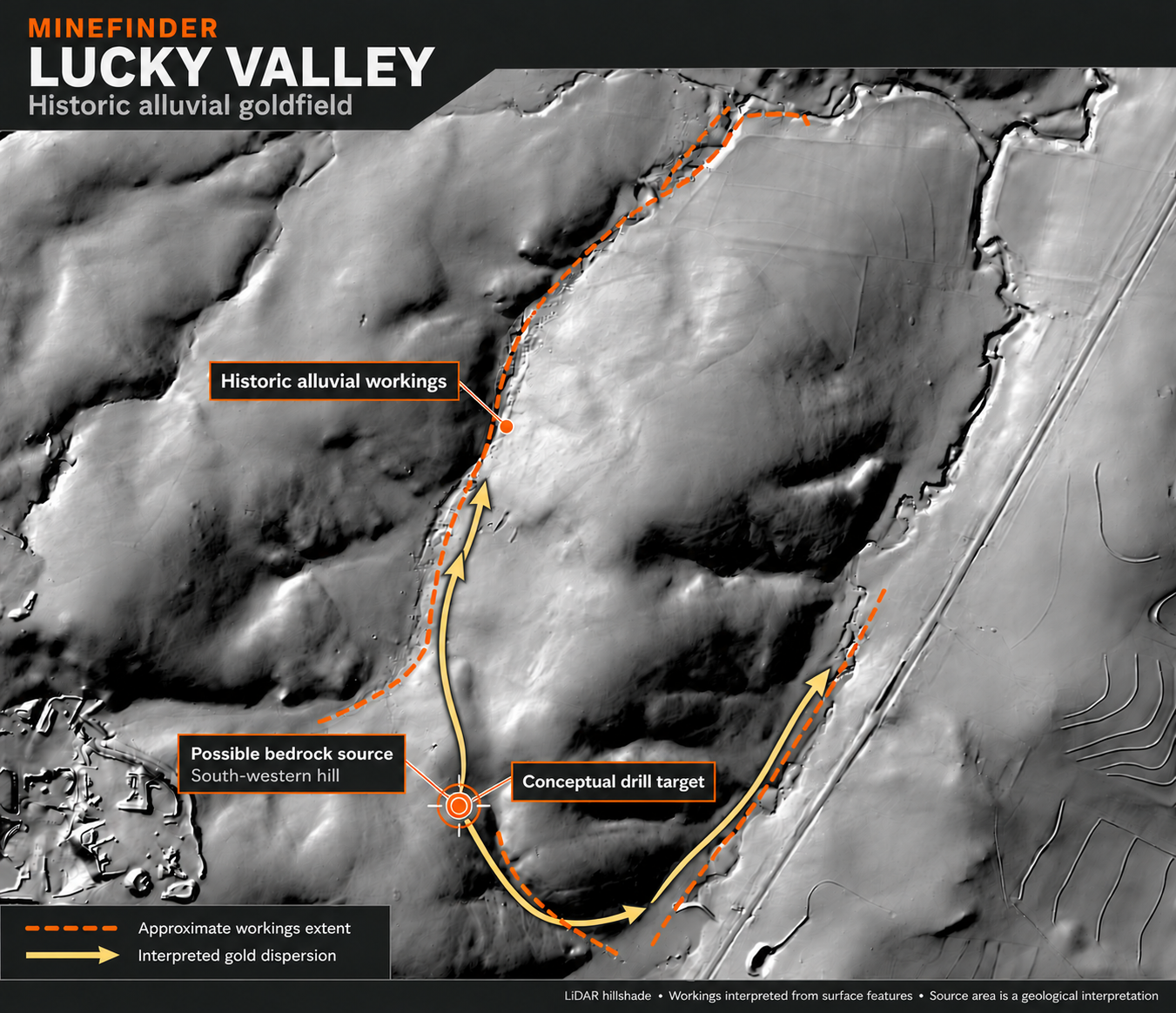
Lucky Valley alluvial field and possible bedrock source. Orange dashes mark the approximate workings extent. Gold-coloured arrows show interpreted dispersion from the south-western hill, where a conceptual drill target is marked. View full-size map ↗
The alluvial field records where gold accumulated
Alluvial gold begins with gold released from mineralised rock by weathering and erosion. Material moves down slopes and through drainage systems. Water transports and sorts the sediment, concentrating dense gold particles in favourable places within gravel, along bedrock surfaces and in natural traps.
Historical miners worked those concentrations. Their diggings therefore preserve a spatial record of the ground they investigated and mined. For modern exploration, the distribution of those workings can help identify pathways back towards the source of the gold.
What the LiDAR adds
The LiDAR hillshade makes small changes in surface relief visible, including the pockmarked ground associated with the historical diggings. This allows the workings to be considered together with the surrounding hills, gullies and drainage corridors, rather than as isolated points on a map.
That relationship is important. A line of workings may follow gold-bearing gravel along a drainage route. Workings that extend towards higher ground may help define a source area or a transition into slope deposits. Mapping these patterns gives us a basis for deciding where to investigate next.
Why investigate the south-western hill?
Our working hypothesis is that gold-bearing rock on or around the south-western hill contributed gold to the nearby alluvial field. The arrows show this proposed relationship, while the target symbol marks a conceptual area for further investigation.
The archived history adds a useful lead: it describes quartz leaders with visible gold on a small hill at the head of Lucky Valley, above the worked gullies. Relocating those leaders and the associated shaft would establish how the historical account relates to the hill identified in this interpretation.
The key test is whether gold and its geological indicators can be traced from the worked ground towards mineralised bedrock on the hill. The elevation model, drainage catchments and field observations will help establish whether those transport paths are plausible. Older drainage routes, reworked gravels and other nearby source areas also need to be considered when testing the interpretation.
The opportunity is to find the bedrock source
The surface workings show where gold accumulated after erosion. Locating the source would allow us to investigate the rock that supplied it. If mineralisation remains beneath the weathered surface, it could provide targets for testing grade, width and continuity at depth and along geological structures.
This is the distinction between following gold in loose surface material and defining a bedrock exploration target. The target could be a vein, a group of structures or a broader mineralised zone. Mapping, sampling and drilling would establish which model applies. The extent of the alluvial workings alone does not determine the size or grade of the source.
How we would test the interpretation
Map the workings and terrain. Trace the pits and worked corridors in the LiDAR, examine elevation profiles and check their relationship to present and former drainage. Ground observations would distinguish stream gravels, slope material and weathered bedrock.
Follow the gold towards its source. Collect systematic rock and soil samples across the hill and its flanks. Map veins, alteration, faults and rock contacts, and compare the results with the distribution of the alluvial workings.
Define targets for drilling. Combine the geological observations, assays and terrain model to identify where mineralised structures may continue beneath the surface. These results would determine drill locations, directions and depths. The symbol on the map represents the source hypothesis, rather than a surveyed drill collar.
Why this matters to MineFinder
The LiDAR interpretation gives the next exploration programme a specific area and a clear question. Early work can test whether the hill supplied the alluvial gold, then focus further spending on the geological features that explain the results.
Establishing a bedrock target would provide a stronger basis for planning a drilling programme, estimating its cost and discussing a partnership or separately funded exploration programme. Lucky Valley’s historical workings are therefore useful both as evidence of past gold activity and as a guide to the next stage of discovery.
A major regional fault has displaced rocks correlated with Silverwood. Reconstructing that history can sharpen the search for intrusive centres, mineralised structures and preserved parts of older systems.
Research, geological timeline and district map · Related projects: Vulcan · Lucky Valley
BE PART OF OUR NEXT DISCOVERY
Interested in Lucky Valley?
Discuss valuation, use of funds, project priorities and investment terms.
The early discovery chronology, gazettal date, named gullies and nineteenth-century mining accounts come from Lucky Valley Gold & Mineral Field, retained as Lucky Valley Gold.pdf (2015) and in Lucky Valley.docx. The text was checked against archived scans of book pages 37–39. The compilation quotes Clarke’s 1853 letter and contemporary newspaper accounts; those original documents have not been independently reconciled here. The two reported early shaft-production returns differ and are presented with their respective sources.
The prospect assays, bulk testing, soil maximum and 6 km/11 km geological interpretation are compiled in CR76849, sections 5.1.1–5.1.6 and Figure 4. That review cites Macaulay (1990), CR21410, and Walker (1988), CR18554 for earlier results. Sample maxima, historical ore returns, soil geochemistry and shallow bulk tests describe different evidence types. The drilling statement applies to the 2013 review.
CR22506 supports the regional exploration chronology and covers a wider area extending from Lucky Valley towards Silverwood. Its regional results are not all attributed to the Lucky Valley project. Current project boundaries and field access will define the areas available for investigation. The LiDAR source area and drill target are MineFinder interpretations; the historical hill has yet to be matched to a surveyed location.