Warroo district, south-east Queensland · Gold, copper and silver
100% MineFinder
Brownfields exploration
Why we selected it: Historical mining and high-grade drill results provide a starting point to test for a district-defining gold–copper discovery.
Historical drilling returned 6 m at 38.9 g/t gold, including 1 m at 120 g/t, and 2 m at 5.50% copper with 5.77 g/t gold. Colossus targets extensions beneath and beyond the Warroo district’s historical workings. 100% owned by MineFinder.
A revised intrusion-associated gold model targets mineralisation beneath and beyond shallow workings, within a 2 km gold–copper-rich zone and a broader 15 km mineralised zone.
Does gold–copper mineralisation beneath and beyond the workings form part of a larger intrusion-related system? Test continuity, grade and geological relationships to guide further drilling.
Historical drilling: 6 m at 38.9 g/t gold, including 1 m at 120 g/t; and 2 m at 5.50% copper with 5.77 g/t gold, including 1 m at 8.70% copper. Selected downhole intervals from the compiled historical database.
Complete pre-listing MAGMA targeting and drill design. Following the proposed listing and associated financing, test gold–copper widths, continuity and depth extensions with RC and diamond drilling.
Proposed
Test budget: Major drilling planned after the proposed listing financing; final scope and costs to follow contractor quotations.
Target timing: Target major drilling from Q2 2027 after the proposed listing and associated financing, subject to access, approvals and contractor availability.
Pre-listing MAGMA work will refine targets and the drilling design. Major drilling is planned from Q2 2027 after the proposed Canadian TSXV CPC listing and associated financing, subject to access, approvals and contractor availability.
No historical core or usable samples survive. New drilling will test gold–copper mineralisation beneath and beyond the workings and obtain fresh material to assess whether it forms part of a larger intrusion-related system.
Proposed drilling methods and geological tests
Method
Purpose
Reverse-circulation (RC)
Test mineralised widths, grades and continuity across several targets. Obtain samples for gold and multi-element assays.
Diamond core
Preserve vein, sulphide, alteration and structural relationships. Obtain samples for petrography and, where suitable, fluid-inclusion studies.
The core will sample mineralisation and its surrounding alteration. Together, the results will assess intrusion-related gold and porphyry copper–gold interpretations and identify geological changes that could guide exploration towards a larger mineralised centre.
Initial diamond results will inform the remaining drilling. Final collars, depths and drilling mix will follow review of historical sections, access and contractor quotations.
Selected historical drilling from Warroo and Commodore. Depths and lengths are downhole metres; true widths and the extent of mineralisation remaining after mining require determination.
Selected historical drill intersections
Hole
From–to (m)
Length (m)
Gold (g/t)
Copper (%)
Context
BRC039
31–37
6.0
38.9
0.040
Includes 1 m at 120 g/t Au, 32–33 m
BRC026
22–26
4.0
23.26
0.186
Calculated composite
BRC091
33–35
2.0
5.77
5.50
Includes 1 m at 8.70% Cu and 10.1 g/t Au, 34–35 m
DDH2 · Commodore
46–47
1.0
0.07
4.67
Historical diamond drilling
RWARC001 · Oxiana
237–239
2.0
4.21
0.52
Calculated composite
RWARC002 · Oxiana
84–85
1.0
0.13
1.64
Historical RC drilling
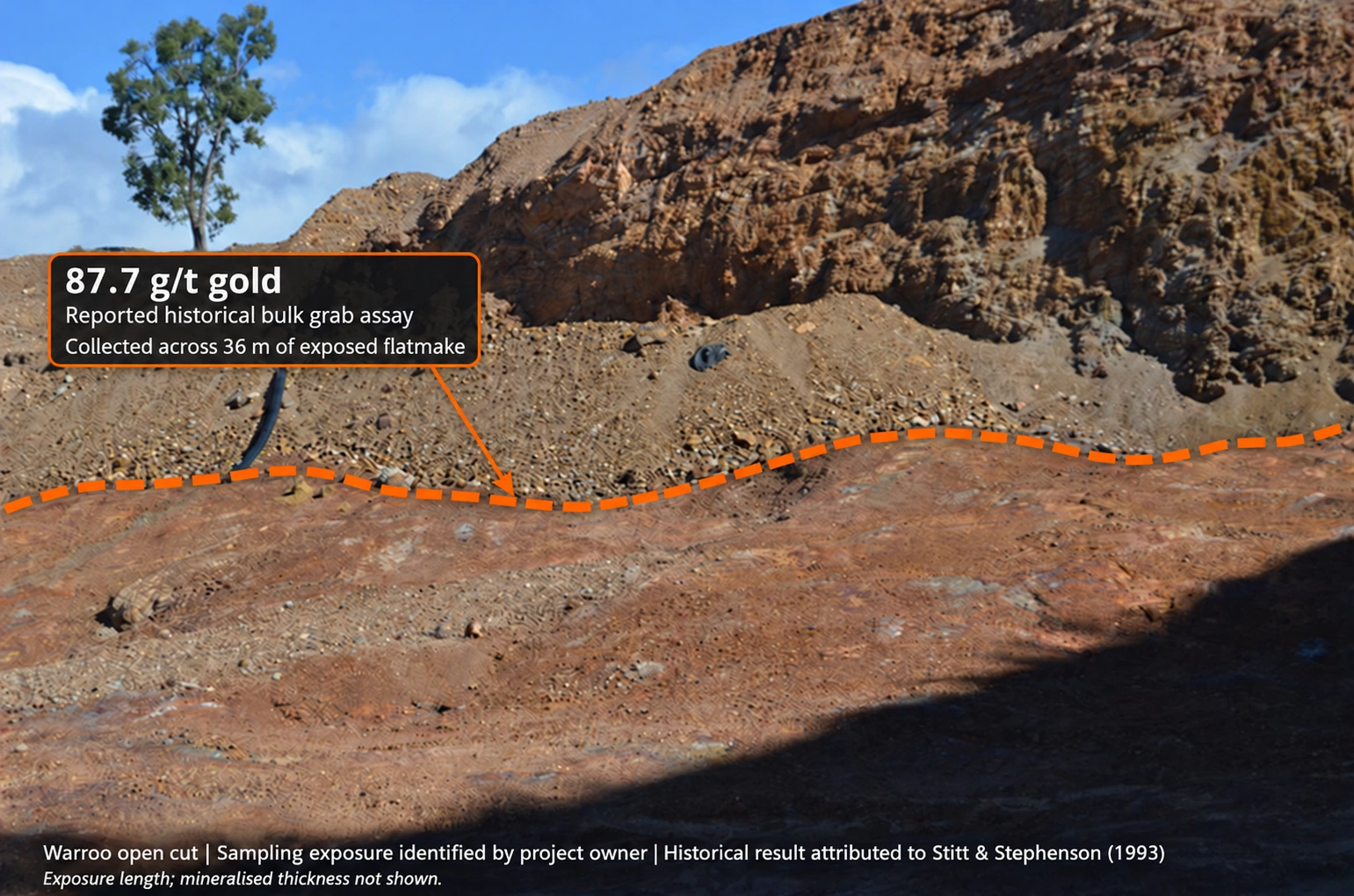
Warroo flatmake exposure: reported 87.7 g/t gold bulk grab assay. The orange line identifies the exposure indicated by the project owner. The reported 36 m refers to the extent from which material was collected; it does not describe a continuous channel interval or mineralised thickness.
Investigating the source of the gold and copper
Placer Dome commissioned Fullagar Geophysics to investigate concealed intrusive bodies in the Warroo district. The 2004 annual report records an interpreted buried intrusion and a fracture corridor linking the Warroo and Ashton prospect groups.
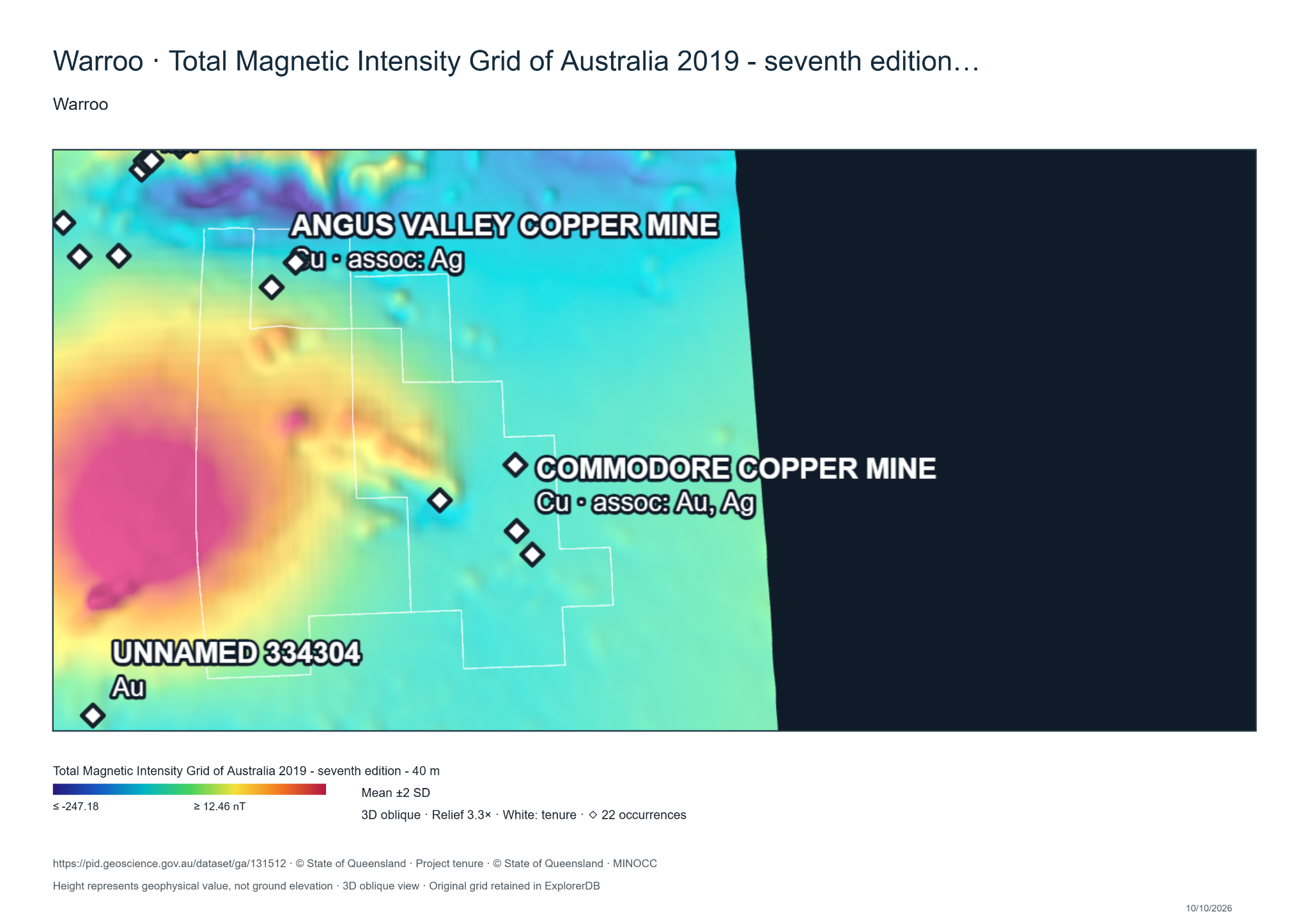
MineFinder’s magnetic visualisations show several known occurrences in relatively subdued magnetic zones beside stronger features. These relationships support investigation of the corridor and possible intrusive margins. Combining magnetics with historical drilling, alteration and geochemistry can help identify extensions and possible source areas beyond the known workings.
Magnetic context for the known mineralisation. Original Mineral Data Studio export by Warwick Anderson, 10 October 2026. Data: Geoscience Australia, 2019 TMI grid, 40 m cells; occurrence and tenure overlays: Queensland Government. Vertical relief represents magnetic values. Read the Placer–Fullagar interpretation and magnetic analysis →
High-grade copper–gold occurrences, possible concealed intrusions and a district of intersecting structures give Colossus a substantial geological question: could the known workings be expressions of a larger porphyry-related mineral system?
Historical drilling, structural and alteration maps, USGS regional context and a programme to test the model · Colossus project
Drill table: 2022 historical compilation, DH_Assays; original report references CR18894, CR21233 and CR49512. Composite grades are length-weighted means of complete adjacent intervals, rounded as shown. BRC039 includes 50–60% sample return at 36–37 m. BRC091 records no return from 35 m. Original Oxiana Tables 2–3 corroborate the RWARC001 and RWARC002 results. Rock-chip maximum: Duval CR13910, printed page 5. Selective rock chips and bulk grabs are distinct from drill intersections.
Flatmake assay: historical wording attributed to Stitt & Stephenson (1993), reproduced in Warwick Anderson’s linked quotation. The original 1993 report, assay certificate, sample mass and collection plan remain to be located. Photograph: sampling exposure identified by the project owner; orange line is illustrative and is not a surveyed sampling boundary.