EPM 26178 and EPM 27725; approximately 282 km². Priority targets on company-reported granted tenure.
Project stage
Brownfields exploration
Current priority
Pre-listing MAGMA targeting and drill design for Warroo, Warroo Southwest and the Warroo–Commodore corridor.
Ownership
100% MineFinder
Colossus is a brownfields gold–copper–silver exploration project in the Warroo district of southeast Queensland. It brings together the historical Warroo, Commodore, Glenrosa and Ashton centres with Ti-Tree Ridge and Angus Valley across approximately 282 km², comprising EPM 26178 and EPM 27725. MineFinder owns 100% of the project.
The current geological interpretation identifies a 2 km gold–copper-rich zone within a broader 15 km mineralised zone. Historical mining focused on shallow gold. Our revised geological model targets a larger intrusion-associated gold system beneath and beyond the old workings. Historical drilling includes 6 m at 38.9 g/t gold, including 1 m at 120 g/t, and 2 m at 5.50% copper with 5.77 g/t gold. These results, mineralised quartz veins, shears and replacement zones provide a basis for targeted follow-up. The first proposed drilling fences focus on Warroo, Warroo Southwest and the Warroo–Commodore corridor. Ti-Tree remains a target for the revised vein interpretation.
Repeated mineralised centres occupy intersecting northwest and northeast structural corridors. The proposed first drilling programme will test primary mineralisation beneath and beyond historical workings, with follow-up guided by the results.
The opportunity
The opportunity is a larger intrusion-associated system beneath and beyond the historical workings. The current interpretation identifies a 2 km gold–copper-rich zone within a 15 km mineralised zone. These dimensions describe the interpreted mineralised setting; they do not establish continuous grade or a Mineral Resource.
Colossus offers several opportunities to extend a known mineralised district: primary sulphides below shallow oxide workings, mineralisation along existing structures and concealed targets beneath adjacent cover. The Warroo–Commodore alteration and mineralisation trend extends over more than 1 km of strike, while Glenrosa has strong alteration over several hundred metres. Ashton–Angus Valley provides a further structural centre.
Priority positions include extensions south and southeast of Warroo, covered ground east of the Warroo–Commodore ridge, the Glenrosa corridor, Ashton beneath alluvium to the east and the reinterpreted Ti-Tree Ridge vein. Evidence of repeatable mineralised geometry would support more focused step-out drilling and assessment of the district’s scale.
MineFinder interpretation
Investment thesis
Does primary gold–copper mineralisation beneath and beyond the historical workings form part of a larger system with sufficient grade and scale to justify further drilling?
RC drilling will test mineralised widths, grades and continuity across several targets. Selected diamond holes will preserve vein sequences, sulphides, alteration and structural relationships. Together, the results will assess intrusion-related gold and porphyry copper–gold interpretations and identify geological changes that could guide exploration towards a larger mineralised centre. These are working interpretations within a broader intrusive mineral system.
Earlier operators tested sheeted-vein targets, and weakly pyritic sedimentary rocks explained some geophysical responses. Target selection will combine structure, alteration and geochemistry with the historical drilling and geophysical interpretations.
Exploration history
Colossus has a long history of small-scale mining, shallow workings and successive exploration campaigns. Warroo and Commodore were worked for gold and copper in the early twentieth century. A later Warroo heap-leach campaign treated approximately 214,000 tonnes at 1.94 g/t Au during 1990–1992.
This history provides exposed structures, historical drilling and operating records for the next evaluation. The present opportunity focuses on deeper primary sulphides and covered extensions beyond the shallow zones previously worked. Historical mining demonstrates extraction from parts of the district; the performance and viability of any new operation would require a separate assessment.
Targeting opportunity
The exploration model has broadened as successive campaigns added geological evidence. Duval’s 1984–1986 Pikedale programme initially targeted Carlin-style disseminated replacement and stockwork gold. Later Valdora exploration and mining exposed the orebody geometry and the importance of low-angle flatmake structures. Regional structural interpretation, magnetic and radiometric data, mapping, soils, rock chips and IP/resistivity added further targeting information.
The current interpretation emphasises structurally controlled, intrusion-associated gold, including intrusive centres around Mt Bullanganang, possible buried satellites and repeated northwest–northeast structural intersections. Ti-Tree adds a local epithermal-style vein target, where later costeaning suggested a shallow north-dipping vein geometry that may have been incompletely tested by earlier drill orientation.
Historical drilling also sharpened the use of geophysics: several Warroo and Warroo Southwest chargeability anomalies intersected principally weakly pyritic black shale. Future targeting therefore needs coincident structure, alteration and geochemistry rather than chargeability alone.
Historical results
Historical RC drilling at Warroo returned 6 m at 38.9 g/t Au in BRC039 from 31–37 m, including 1 m at 120 g/t Au from 32–33 m. BRC026 returned a calculated 4 m at 23.26 g/t Au from 22–26 m. The later historical drill compilation supports both intersections.
Copper–gold drilling includes a calculated 2 m at 5.50% Cu and 5.77 g/t Au in BRC091 from 33–35 m, including 1 m at 8.70% Cu and 10.1 g/t Au from 34–35 m. At Commodore, diamond hole DDH2 returned 1 m at 4.67% Cu from 46–47 m. Oxiana hole RWARC001 returned a calculated 2 m at 4.21 g/t Au and 0.52% Cu from 237–239 m, while RWARC002 returned 1 m at 1.64% Cu from 84–85 m. Reported lengths are downhole intervals. True widths and the extent of mineralisation remaining after historical mining require determination.
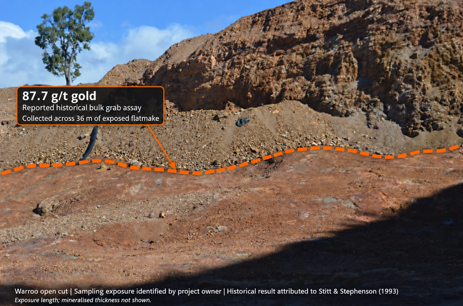
A historical bulk random grab sample reportedly assayed 87.7 g/t Au. Material was collected across 36 m of flatmake exposed at the base of the Warroo open cut, according to wording attributed to Stitt & Stephenson (1993). The 36 m describes the sampled exposure extent, rather than a continuous drill or channel interval. The project owner identified the exposure shown in the annotated photograph.
Duval’s original 1984 report records selective Warroo rock-chip assays up to 40.2 g/t Au. Early Ti-Tree rock chips returned 2.3 g/t Au and later sampling peaked at 10.9 g/t Au. These samples demonstrate local mineralisation; systematic sampling and drilling will test its distribution.
A historical open-cut mineable resource was reported as approximately 160,000 tonnes at 2.86 g/t Au, using a 0.5 g/t cut-off. This equates to approximately 14,700 oz of contained gold and is a historical estimate, not a current mineral resource or a measure of recovered production. Separately, approximately 214,000 tonnes at 1.94 g/t Au were reportedly treated in the 1990–1992 heap-leach campaign.
Earlier Warroo production is reported as 21 tonnes of copper, 283 oz gold and 901 oz silver during 1910–1911, followed by 923–932 oz gold from tributers during 1912–1913. In 1931, eight tonnes of ore reportedly yielded 5 oz gold. Commodore reportedly produced 206 tonnes of copper during 1906–1912 from a supergene zone described at 6–25% Cu with local gold up to 25 g/t.
Field evidence includes a 300 m by 60 m zone of interest around Warroo, a 400 m by 80 m geochemical zone at Glenrosa, repeated altered and sulphidic structures, and As, Sb, Bi, Hg, Ba, Mo, Cu, Pb and Zn anomalies. A reported SRS geochemical comparison with Kensington helps guide the geological interpretation.
Original drill logs, assays, sampling methods and QA/QC records will support the next stage of technical evaluation.
High-grade gold and copper–gold intersections
Selected historical drilling from Warroo and Commodore. Depths and lengths are downhole metres; true widths and the extent of mineralisation remaining after mining require determination.
Selected historical drill intersections
Hole
From–to (m)
Length (m)
Gold (g/t)
Copper (%)
Context
BRC039
31–37
6.0
38.9
0.040
Includes 1 m at 120 g/t Au, 32–33 m
BRC026
22–26
4.0
23.26
0.186
Calculated composite
BRC091
33–35
2.0
5.77
5.50
Includes 1 m at 8.70% Cu and 10.1 g/t Au, 34–35 m
DDH2 · Commodore
46–47
1.0
0.07
4.67
Historical diamond drilling
RWARC001 · Oxiana
237–239
2.0
4.21
0.52
Calculated composite
RWARC002 · Oxiana
84–85
1.0
0.13
1.64
Historical RC drilling
Warroo flatmake exposure: reported 87.7 g/t gold bulk grab assay. The orange line identifies the exposure indicated by the project owner. The reported 36 m refers to the extent from which material was collected; it does not describe a continuous channel interval or mineralised thickness.
MineFinder interpretation
Geological model
Colossus lies within the New England Orogen, principally in Late Devonian to Early Carboniferous Texas Beds turbiditic and volcaniclastic sediments, with local volcanic units, Permian outliers and intrusions. The succession is strongly deformed, steeply dipping and locally overturned. Regional deformation and the Texas Orocline influence its structural architecture.
At Warroo and Commodore, mineralisation occurs in pyritic shale, siltstone and tuffaceous metasediments with silicification, jasperoid-like replacement and quartz–carbonate veins. Reported minerals include pyrite, arsenopyrite and chalcopyrite, with minor sphalerite and secondary copper minerals. Both primary sulphide-associated gold and supergene enrichment are described.
The working model links steep shears and fluid conduits with lower-angle flatmake thrust or detachment structures, feeder fractures and subsidiary east to northeast splays. Flatmakes are interpreted as favourable sites for primary deposition and later supergene upgrading.
Intrusive proximity, potassic and silica alteration, polymetallic pathfinders and repeated structural intersections support an intrusion-associated hydrothermal interpretation at district scale. Ti-Tree has a local epithermal vein–breccia expression. Individual prospects may represent different parts of this broader system, and the genetic relationships require testing. Colossus’s structural gold–copper model is distinct from Vulcan’s volcanic–carbonate sulphide framework.
Technical objectives
The next technical work will define the continuity and dimensions of the mineralised corridors, locate primary feeders and test relationships between prospects. Glenrosa provides a specific target: explain the strong alteration and its relationship to gold distribution.
Drilling and representative sampling will establish mineralised thickness, grade distribution and structural geometry. These results can support subsequent resource and metallurgical assessment.
Field planning includes permit conditions, landholder access, programme design, approvals and funding.
Proposed
Next milestones
Test budget
Major drilling planned after the proposed listing financing; final scope and costs to follow contractor quotations.
Target timing
Target major drilling from Q2 2027 after the proposed listing and associated financing, subject to access, approvals and contractor availability.
Before listing, MAGMA will integrate the historical data and refine the geological models and exploration targets. Major drilling is planned from Q2 2027 after the proposed Canadian TSXV CPC listing and associated financing.
The proposed first programme combines reverse-circulation (RC) drilling with selected diamond holes beneath and beyond historical workings. Initial targets are Warroo, Warroo Southwest and the Warroo–Commodore corridor. RC drilling will test mineralised widths, grades and continuity. Diamond drilling will preserve vein, sulphide, alteration and structural relationships to assess intrusion-related gold and porphyry copper–gold interpretations and guide exploration towards a possible larger mineralised centre.
No historical core or usable samples survive. New diamond core will provide fresh material for petrography and, where suitable quartz is present, fluid-inclusion studies. Core will sample mineralisation and surrounding alteration. Multi-element assays will assess whether gold, copper and pathfinder elements form a coherent pattern.
The indicative design basis is 8–12 RC holes totalling approximately 1,200–1,800 m and two diamond holes totalling approximately 400–600 m: 10–14 holes and 1,600–2,400 m overall. RC pre-collars may be used where suitable; core recovery must start above the intervals needed for geological interpretation. Pre-collar metres are included within the total programme, not added to it. Final collars, depths and drilling mix will follow review of historical sections, access and contractor quotations.
The mixed programme will be funded through the proposed listing financing and costed to include drilling, assays, geological studies, access, rehabilitation and contingency. Quantities will be adjusted to confirmed costs. Mobilisation requires funding, access agreements, approvals and contractor availability; the schedule will follow drilling and laboratory quotations. The owned scout rig can test suitable early targets; rig selection will follow the final mixed programme design.
Core will be photographed and logged for lithology, vein density, cross-cutting relationships, sulphides and alteration, with orientation where ground conditions permit. Sampling will include representative mineralisation and wall rock, with blanks, certified reference materials and duplicates. Initial diamond results will inform the remaining drilling. Mineralised extensions and coherent alteration and metal patterns would support further exploration; narrow isolated veins without a broader envelope would weaken the scale case. Missed targets or poor recovery require assessment before a geological conclusion.
Investment discipline
The key decision is whether initial testing supports coherent primary mineralisation with geometry that can be followed in subsequent holes. Warroo tests will examine feeder and flatmake relationships; Ti-Tree tests will evaluate the north-dipping vein model.
Mineralised thickness, grade distribution and structural continuity will guide step-out drilling and model refinement. Target selection will combine geophysics with structure, alteration and geochemistry.
Ownership and commercial pathway
MineFinder owns 100% of Colossus, providing direct exposure to exploration results and future project decisions.
Any later partnership or transaction would establish its own ownership, funding and retained-interest terms.
THE REGIONAL SETTING
Regional context
Regional geology and deposit analogues help us develop exploration models and select features to test at each project.
High-grade copper–gold occurrences, possible concealed intrusions and a district of intersecting structures give Colossus a substantial geological question: could the known workings be expressions of a larger porphyry-related mineral system?
Historical drilling, structural and alteration maps, USGS regional context and a programme to test the model · Colossus project
A full review of shallow-dipping flatmake mineralisation, structural and chemical controls, international comparisons and the proposed application at Warroo.
Why this matters to Colossus
The original article explicitly discusses the Warroo Gold Mine, part of the Colossus project. Its flatmake model can be compared with the project’s historical drilling and mapped low-angle structures. The proposed model requires project-scale testing; comparisons with other deposits do not establish continuity, grade or resources at Colossus.
Source article · original references retained · Article revision 1
The full review of the Texas Orocline’s structural architecture, historical goldfields, endowment indicators and the evidence needed to test regional gold potential.
Why this matters to Colossus
The source’s Warwick–Texas district discussion includes the historical Waroo (Warroo) mine. Colossus is the Warroo project, so this article provides district-scale structural and mining context. The regional endowment discussion is not a resource estimate or evidence of deposit continuity at Colossus.
Source article · original references retained · Article revision 1
Drill table: 2022 historical compilation, DH_Assays; original report references CR18894, CR21233 and CR49512. Composite grades are length-weighted means of complete adjacent intervals, rounded as shown. BRC039 includes 50–60% sample return at 36–37 m. BRC091 records no return from 35 m. Original Oxiana Tables 2–3 corroborate the RWARC001 and RWARC002 results. Rock-chip maximum: Duval CR13910, printed page 5. Selective rock chips and bulk grabs are distinct from drill intersections.
Flatmake assay: historical wording attributed to Stitt & Stephenson (1993), reproduced in Warwick Anderson’s linked quotation. The original 1993 report, assay certificate, sample mass and collection plan remain to be located. Photograph: sampling exposure identified by the project owner; orange line is illustrative and is not a surveyed sampling boundary.