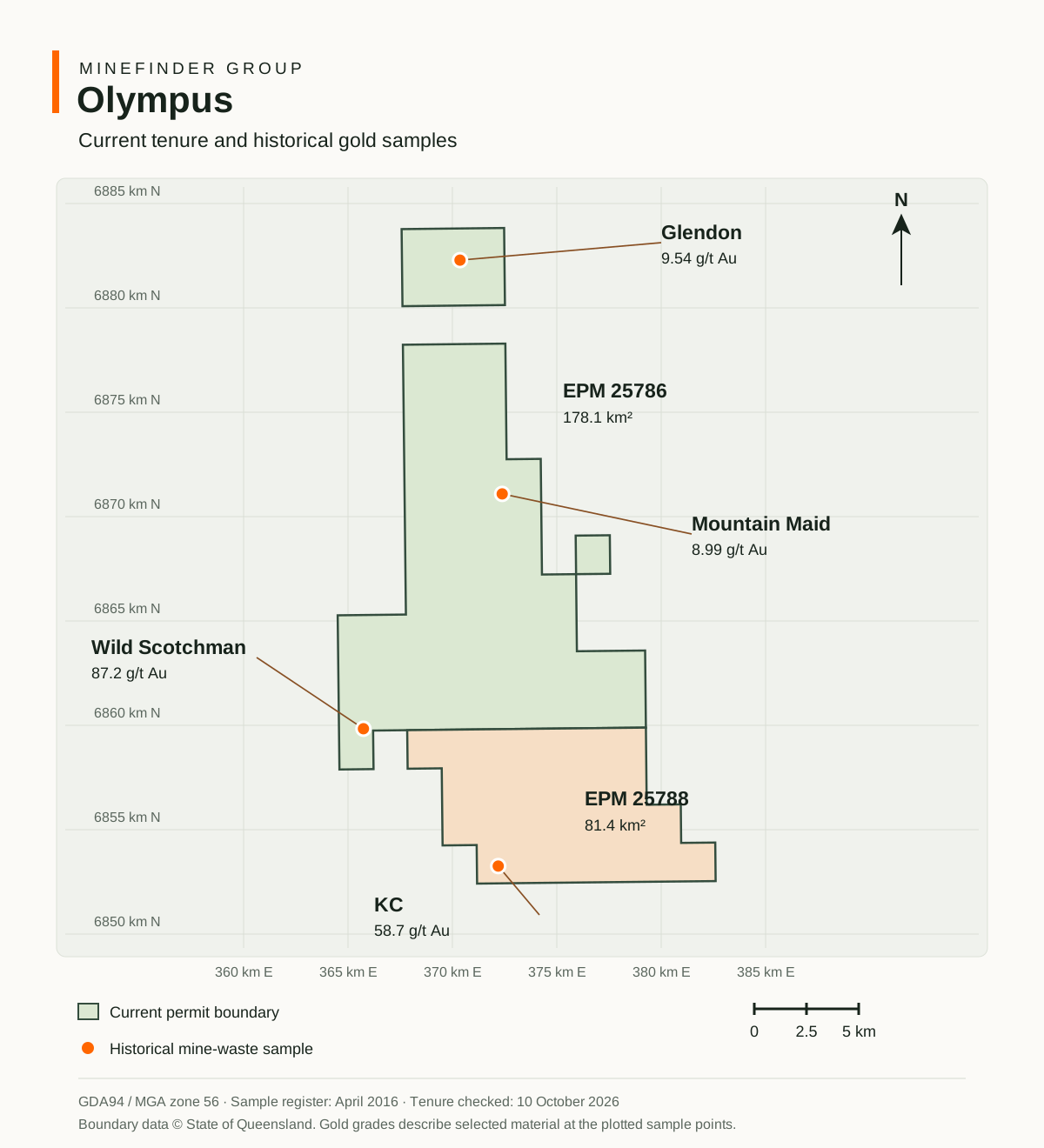
Mapped permits EPM 25786 and EPM 25788: approximately 259.6 km² combined. Both recorded as granted; renewal lodged for EPM 25788. Queensland register checked 10 October 2026.
Project stage
Exploration and target development
Current priority
Progress the proposed gold company with Karara Gold and define bedrock targets beneath and between historical workings.
Ownership
100% MineFinder
High-grade gold, black sedimentary rocks, sulphides and fold structures give Olympus a geological basis for comparison with Sukhoi Log and Muruntau. MineFinder is testing whether the old workings expose part of a much larger gold system in the surrounding rocks and at depth.
The comparison rests on black slate and shale, sulphides, quartz veins and interpreted fold and fault structures. Historical exploration reports identify both deposits as target models. Sukhoi Log has reported Mineral Resources of 81 million ounces of gold; the combined Muruntau–Myutenbay deposit has 90.5 million ounces. These are the analogue deposits’ reported resources.
MineFinder is integrating the mine records, structural mapping, geochemistry and magnetic data to identify broader mineralised zones and repeated favourable settings beneath and between the old mines. MineFinder owns 100% of Olympus. MineFinder is in discussions with Karara Gold about combining Olympus with Karara Gold’s adjoining tenements in a dedicated gold company. External investors would fund the new company while MineFinder retains equity.
The opportunity
The opportunity is to find a substantial bedrock gold system beneath and beyond the historical workings. The old mines expose mineralised structures and provide specific starting points for exploration.
At Mountain Maid, workings extend for at least 650 m. Madam Ross has workings over 750 m, approximately 3 km away. These are extents of historical workings. MineFinder will assess the structures between and below them to identify targets for drilling.
MineFinder interpretation
Investment thesis
Do the historical high-grade reefs form part of a much larger bedrock gold system?
The Sukhoi Log comparison directs exploration towards folded, sulphidic sedimentary rocks. The Muruntau comparison directs exploration towards veins, stockworks and altered host rocks around major structures. MineFinder will test the distribution of gold across these settings, their depth extensions and where favourable structures repeat.
Exploration history
Historical mining followed gold-bearing quartz reefs at several centres. The mine plans, exposed workings and sample records provide a substantial geological archive for modern target assessment.
In 1989, five shallow exploration holes totalled 197 m: three at Mountain Maid and two at Madam Ross. MineFinder’s current assessment will use the historical drilling and mine geometry to design tests of the revised structural model.
MineFinder interpretation
Targeting opportunity
MineFinder is bringing the historical mine records, structural mapping, geochemistry and magnetic data into one geological assessment. The aim is to identify the structures that carried gold-bearing fluids and the positions where those fluids deposited gold.
At Mountain Maid–Telegraph, the mapped structures and a nearby magnetic response provide specific targets to investigate. Their relationship is a geological interpretation to test through fieldwork and drilling.
Historical results
At KC, historical underground sampling recorded 207 g/t gold from a pillar. The rock-sample register also records selected mine-waste samples of 87.2 g/t at Wild Scotchman, 58.7 g/t at KC and 8.99 g/t at Mountain Maid. The results below retain their original sample types.
The extent of historical workings at Mountain Maid and Madam Ross adds a separate measure of the exploration setting. Sampling identifies gold-bearing material; the next programme will test the width, grade and continuity of the structures that host it.
GOLD IN THE HISTORICAL RECORD
High-grade gold at named prospects
Historical underground sampling and selected specimens from mine-waste heaps provide specific locations for follow-up.
Selected historical gold results
Prospect
Gold (g/t)
Sample type
Sample record
KC
207
Historical underground pillar sample
Mine record cited in the 2021 geological review
Wild Scotchman
87.2
Selected mine-waste sample
F95/14 · quartz vein
KC
58.7
Selected mine-waste sample
F17/14 · quartz vein
Glendon
9.54
Selected mine-waste sample
2016 register, sample 150 · quartz vein
Mountain Maid
8.99
Selected mine-waste sample
F37/14 · sheared fault rock
Grades describe the selected material sampled. They are separate from drill intersections, continuous sampling intervals and average deposit grades.
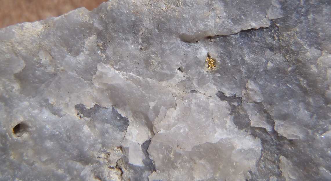
Current tenure and historical sample locations. EPM 25786 and EPM 25788 total approximately 259.6 km². Both are recorded as granted; renewal is lodged for EPM 25788. Sample points use the April 2016 register coordinates. The KC point locates the 58.7 g/t mine-waste sample. View full-size map ↗Visible gold in quartz, Glendon area. Historical field photograph of a quartz-vein specimen from mine waste at Mt Robinson. The photograph illustrates the mineralisation; no assay is assigned to this specimen.
MineFinder interpretation
Geological model
Olympus offers a specific exploration opportunity: test whether its historical high-grade reefs are part of a much larger gold system in the surrounding sedimentary rocks. The combination of black slate and shale, folds, faults, quartz veins and sulphides provides the basis for comparison with Sukhoi Log and Muruntau.
The 2022 exploration reports explicitly identify both deposits as target models. Their relevance is geological: they show how gold can occur across favourable host rocks and structures, with high-grade veins forming part of a broader mineralised system.
Sukhoi Log, Russia: 81 million ounces of gold in Mineral Resources. Total Measured, Indicated and Inferred Mineral Resources at 31 December 2024. Gold associated with pyritic sedimentary rocks, folded veins and an overturned anticline.
Muruntau–Myutenbay, Uzbekistan: 90.5 million ounces of gold in Mineral Resources. Combined deposit: 76.3 million ounces Measured and Indicated, plus 14.2 million ounces Inferred. Reported in April 2026. Muruntau provides a comparison for structurally controlled veins and stockworks in altered sedimentary rocks.
These figures describe the analogue deposits; they are not a resource estimate or a prediction of deposit size at Olympus.
Sukhoi Log: folded, pyritic sedimentary rocks
At Sukhoi Log, gold occurs in organic-rich, pyritic shale and siltstone folded into a tight overturned anticline. Gold occurs in both disseminated pyrite and folded pyrite–quartz veinlets. Published research describes several stages of gold concentration and redistribution during sediment burial, metamorphism and deformation.
Comparable host-rock setting. Mountain Maid and Madam Ross occur in black slate and sandstone. Telegraph has pyritic, silicified black shale and sandstone. These observations support testing the sedimentary host rocks themselves for gold, including material between the quartz reefs.
Fold structures to follow. Historical mapping places Mountain Maid and Madam Ross on separate interpreted anticlines, approximately 3 km apart. Fold hinges and repeated favourable beds are specific positions to investigate beneath the workings.
A sulphide-bearing system at depth. Telegraph records describe abundant arsenopyrite and a pyritic reef at approximately 18 metres depth. This provides a direct reason to examine fresh sulphidic rock and determine how much gold occurs within or alongside the sulphides.
The Sukhoi Log model directs exploration towards folded, sulphidic host units and their continuity. Mineralogical work would measure carbon and sulphide content and establish how gold is distributed among the minerals.
Muruntau: gold-bearing veins within a broader altered rock system
At Muruntau, gold-bearing quartz–sulphide veins and stockworks cut altered sedimentary rocks near major faults and folds. Gold is associated with pyrite and arsenopyrite. The mineral system includes both high-grade veins and networks of smaller veins within altered host rock.
Multiple veins and altered wall rock. Mountain Maid is described as a multiple-vein system in fractured, carbonate-altered sandstone. Telegraph contains quartz-veined, silicified sandstone and black shale. These are useful starting points for testing a broader volume of mineralised rock around the known reefs.
Gold in sheared fault rock. A selected historical mine-waste sample from Mountain Maid returned 8.99 g/t gold from fine-grained sheared fault rock (F37/14). This identifies gold-bearing material beyond the quartz-reef specimens and gives a specific target for representative sampling of the surrounding rock.
Structures with substantial mapped extent. Historical workings extend for at least 650 m at Mountain Maid and 750 m at Madam Ross. These lengths describe the workings and provide a framework for testing veins, fractures and altered rocks along strike and at depth.
The Muruntau model directs exploration towards the density and distribution of veins, the width of altered rock and the intersections of faults and folds. The key question is whether the known reefs form part of a broader stockwork or disseminated gold system.
MineFinder is bringing the historical mine geometry, assays and geological observations together to select tests of the larger system. Mapping will trace folds, faults and alteration. Representative sampling will cover both veins and host rocks. Mineralogical studies will identify the gold-bearing minerals, and drilling will test width, grade and continuity beneath the workings.
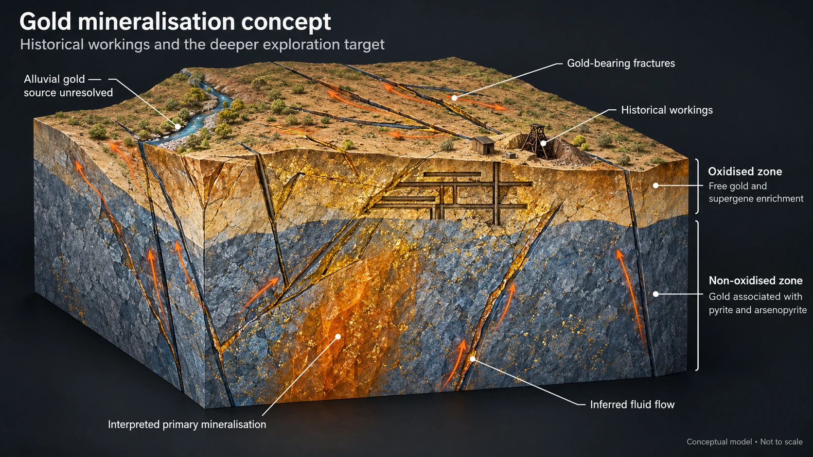
The exploration opportunity beneath the workings. The model shows how gold-bearing fractures may extend from shallow historical workings into deeper primary mineralisation. Mapping and drilling will test these structural connections. Conceptual model; not to scale. View full-size image ↗
Proposed
Technical objectives
The next technical work will determine the orientation and continuity of mineralised structures, the source of the magnetic response and the relationship between quartz reefs and sulphidic rocks.
Mapping and representative sampling will establish surface targets. Drill design will then focus on the most favourable positions beneath the workings and along their structural extensions.
Proposed
Next milestones
The immediate commercial priority is to agree the proposed structure with Karara Gold and prepare a project-specific funding plan. MineFinder aims to progress the spin-out from Q2 2027. The new company would fund the wider exploration programme while MineFinder retains an equity interest.
The technical work supports three linked stages.
1. Reconstruct the mine geometry and integrate historical sampling, drilling and geophysical records.
2. Map and sample priority structures, including the Mountain Maid–Madam Ross setting, and refine the geological model.
3. Design and cost the initial drill programme, with targets selected to test depth continuity and structural connections. Field planning includes landholder access and the approvals required for the proposed work.
The resulting target package will support the proposed gold company and its exploration funding. The transaction remains subject to final terms and approvals.
Proposed
Investment discipline
The programme will test for gold beneath the historical workings and determine whether mineralised structures connect or repeat. Drill results will establish grade, width and geometry at the tested positions and guide the next stage of exploration.
Ownership and commercial pathway
MineFinder owns 100% of Olympus and is in ongoing discussions with Karara Gold to combine Olympus with Karara Gold’s adjoining tenements in a dedicated gold company.
Under the proposed structure, external investors would fund exploration in the new company while MineFinder retains a cornerstone equity stake. This would preserve shareholder exposure to Olympus while allowing MineFinder to fund other project opportunities.
MineFinder is also considering an in-specie distribution of shares in the new company to MineFinder shareholders. The structure, retained interest and any distribution remain subject to final terms and regulatory approvals.
THE REGIONAL SETTING
Regional context
Regional geology and deposit analogues help us develop exploration models and select features to test at each project.
The full review of the Texas Orocline’s structural architecture, historical goldfields, endowment indicators and the evidence needed to test regional gold potential.
Why this matters to Olympus
Olympus is located in the Warwick goldfields. This article reviews the Warwick–Texas district and its structural setting, providing regional background for the project. District-scale comparisons and historical occurrences do not establish mineralisation, grade or continuity on Olympus tenure.
Source article · original references retained · Article revision 1
KC pillar result: historical underground sampling cited in the February 2021 geological review. Selected mine-waste results: original geological compilation, Table 1, and April 2016 sample register. These samples identify gold-bearing material at the stated locations. The Mountain Maid and Madam Ross dimensions describe extents of historical workings.
Tenure: Queensland Government current resource-authority polygons, retrieved 10 October 2026. Area is the sum of the two mapped permit polygons. Sample coordinates: GDA94 / MGA zone 56. Photograph: original geological compilation, Plate 2.