Re-evaluation of a past-producing epithermal system
Current priority
Reconstruct the North Pit vein geometry, investigate the displaced West Pit vein and rank concealed-vein targets.
Ownership
100% MineFinder
Valhalla is a past-producing epithermal gold project in Queensland, recorded as Manumbar in the historical reports. The 2010 prospectus records 293,400 tonnes mined from three pits during 1994–1999, with approximately 49,000 oz recovered at a reported recovered grade of 5.2 g/t Au.
Historical West Lode drilling returned 7 m at 70.6 g/t Au in MW4 from 28–35 m, including a logged 2 m sample at 188 g/t Au from 30–32 m (MWD38). Other reported intersections include 3 m at 90.2 g/t Au in MW22, 2 m at 65.0 g/t Au in MW18, 4 m at 52.3 g/t Au in MW46 and 4 m at 41.8 g/t Au in MW41. These results pre-date West Lode mining.
Drilling below the North Pit returned 6 m at approximately 7.6 g/t Au in DP028, with an estimated true width of 4.2 m. Later drilling in 2016 returned a separate narrow high-grade intersection in MBR011. A fault-displaced vein at West Pit Extended and concealed or parallel veins provide additional targeting questions.
MineFinder will reconstruct the vein geometry and test the exposed epithermal level before defining a costed drilling programme. MineFinder owns the project interest. Tenure remains in application; field work depends on grant, access and approvals. There is no current mineral resource.
MineFinder interpretation
The opportunity
The opportunity is to locate coherent gold-bearing shoots outside the mined areas. Historical production establishes a gold-bearing system. DP028 provides evidence for mineralisation of appreciable grade and estimated true width below the North Pit; MBR011 adds a deeper but much narrower high-grade intersection.
A calcite vein at West Pit Extended was reported to have been sheared off at approximately 40 m depth and never relocated. Concealed and parallel veins provide additional positions to investigate.
The next stage will determine which positions have geometry, width and grade distribution sufficient to justify drilling. Successful tests could support systematic shoot delineation and a future partnership or separately funded exploration company.
MineFinder interpretation
Investment thesis
Can the gold-bearing vein below the North Pit be traced into coherent shoots, can the displaced West Pit Extended vein be relocated, and can concealed or parallel veins be targeted efficiently?
Cameron Switzer’s interpretation proposes that the exposed epithermal level may lie above the main boiling-related gold-deposition zone. Historical textures, alteration and structural observations provide the evidence to test this interpretation. The favourable interval must be located from project-specific evidence, rather than assumed to occur at a fixed depth.
Exploration history
1988 onwards — CRA exploration located the Manumbar gold system. Mining subsequently developed the East, West and North Pit areas.
1994–1999 — The 2010 prospectus records 293,400 tonnes mined and approximately 49,000 oz recovered at a reported recovered grade of 5.2 g/t Au. Ore was trucked to the Shamrock treatment plant. Historical accounts describe heavy rain and flooding during the later mining period.
2004 — D’Aguilar completed six holes totalling 1,820 m, using RC precollars and diamond tails. DP028 returned 6 m at approximately 7.6 g/t Au below the North Pit. Previously unassayed CRA core from MB43 and MB44 also returned gold-bearing intervals below the East Pit.
2012 — Four RC holes totalling 314 m followed up the vein system. MBR004 returned 14 m at 0.626 g/t Au, including 4 m at 1.28 g/t Au.
2016 — Two RC holes with diamond tails totalled 300.2 m. MBR011 returned 0.69 m at 27.9 g/t Au. MBR012 returned no economic intersections according to the report authors.
2017 — EPM 15238 was surrendered effective 23 March. The final report states that finding concealed veins without surface indicators would require prohibitively expensive blind drilling, and suggested that a new geophysical method might help. This is the history of the former permit, separate from MineFinder’s current application.
Proposed
Targeting opportunity
Preliminary target order — based on the reviewed historical evidence. Final drill order will follow reconstruction of the mined areas and vein geometry.
1. North Pit vein: reconcile DP028 with MBR011 and the 2012 holes. The 2017 report interprets DP028 and MBR011 as potentially intersecting the same vein, distinct from the low-grade North Lode. Test the vein position, shoot geometry and remaining width.
2. West Pit Extended: investigate the calcite vein reported to have been sheared off at approximately 40 m depth and never relocated. Reconstruct the fault and displacement before placing a drill target.
3. Concealed and parallel veins: assess covered or deeply weathered vein positions and the Mi Mi Creek/eastern chalcedonic-vein corridor. Establish structural and alteration vectors before drill testing.
The 2017 targeting problem was the cost of drilling without reliable surface indicators. MineFinder’s proposed response combines historical-data reconstruction, vein-stage and alteration studies, and assessment of suitable geophysics. Resistivity or magnetotellurics will first require a demonstration that they can resolve the relevant structures at this project.
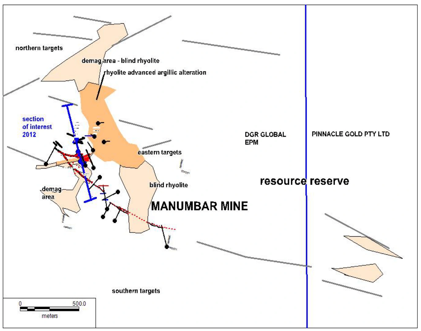
Historical target framework. The historical map retains the Manumbar name. The map shows earlier geological targets and tenure context. Boundaries and holder labels are historical; this is not a map of MineFinder’s current application. The displaced West Pit vein is described in the report conclusions and is not separately located on this figure.
Historical results
Historical West Lode drilling returned 7 m at 70.6 g/t Au in MW4 from 28–35 m, including a logged 2 m sample at 188 g/t Au from 30–32 m (MWD38). Other reported intersections include 3 m at 90.2 g/t Au in MW22, 2 m at 65.0 g/t Au in MW18, 4 m at 52.3 g/t Au in MW46 and 4 m at 41.8 g/t Au in MW41. These results pre-date West Lode mining.
The original 2004 announcement and 2017 final report identify the drill holes, downhole intervals and target settings shown below. DP028 has a reported estimated true width of approximately 4.2 m; other listed interval lengths are downhole lengths with true widths not established here.
The 2016 intersection in MBR011 is high grade but narrow. Its relationship to DP028 is an interpretation in the 2017 report, which calls for further drilling to resolve the vein system. The lower-grade 2012 result and MBR012 outcome are included to show the follow-up evidence.
Historical production is approximately 49,000 oz recovered at a reported recovered grade of 5.2 g/t Au from 293,400 tonnes during 1994–1999, as recorded in the 2010 prospectus. Historical production and drill intersections are separate from a current mineral resource.
Selected historical drill intersections
Au grades are in g/t. Depths and interval lengths are downhole metres. The included MW4 and MBR004 intervals form part of their respective wider intersections.
Results below and near the historical workings
Hole
Drilling / assay year
Position
From–to (m)
Length (m)
Au (g/t)
True width
MW4
1995 report
West Lode; before mining
28.0–35.0
7.0
70.6
Not established
MW4 included sample MWD38
1995 report
Within the 7 m interval; logged assay
30.0–32.0
2.0
188
Not established
MW22
1995 report
West Lode; before mining
32.0–35.0
3.0
90.2
Not established
MW18
1995 report
West Lode; before mining
26.0–28.0
2.0
65.0
Not established
MW46
1996 report
West Lode; before mining
60.0–64.0
4.0
52.3
Not established
MW41
1996 report
West Lode; before mining
48.0–52.0
4.0
41.8
Not established
DP028
2004
North Pit depth test
94.0–100.0
6.0
7.65
≈4.2 m estimated
MB43
1991 core; assayed 2004
Below East Pit
104.0–105.3
1.3
14.5
Not established
MB44
1991 core; assayed 2004
Below East Pit
84.4–85.6
1.2
6.61
Not established
MBR004
2012
North Pit follow-up
52.0–66.0
14.0
0.626
Not established
MBR004 included interval
2012
Within the 14 m interval
58.0–62.0
4.0
1.28
Not established
MBR011 (MBR11)
2016
Below North Pit
123.35–124.04
0.69
27.9
Not established
MBR011 (MBR11)
2016
Lower interval; hole end
132.0–133.2
1.2
2.48
Not established
MBR012 returned no economic intersections according to the 2017 report authors. These selected results describe historical mineralisation; remaining shoot dimensions and grade distribution are the next drilling questions.
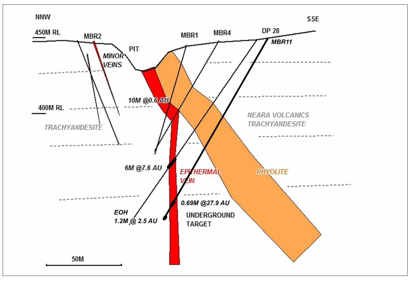
North Pit: drilling below the workings. The red vein geometry is the report authors’ interpretation. MBR11 is MBR011; DP28 is DP028. The figure rounds several assay values. Its MBR4 label shows 10 m at 0.6 g/t; the report text records MBR004 as 14 m at 0.626 g/t. The table follows the report text.
MineFinder interpretation
Geological model
The historical reports describe gold-bearing quartz–calcite veins in Triassic Neara Volcanics, with trachyandesite hosts, local rhyolite dykes and fault controls. Veins pinch and swell, so both structure and hydrothermal level affect the targeting case.
The 2017 report summarises an interpretation that the exposed carbonate-rich vein occupies a high level in an epithermal system, above the main boiling zone. Cameron Switzer’s current interpretation also provides a reason to examine deeper positions. Vein textures, silica–carbonate relationships, alteration and structural reconstruction will test that exposed level.
DP028 and MBR011 establish gold-bearing intersections below the North Pit, but their differing widths require a resolved three-dimensional model. The historical cross-section shows the authors’ interpretation of their relationship; drilling will test continuity, thickness and shoot orientation.
The displaced West Pit vein and concealed veins introduce separate structural targets. The programme must distinguish a favourable gold-deposition interval from an isolated high-grade intersection and account for mineralisation already mined.
Technical objectives
The technical objectives are to reconstruct the mined volume, trace remaining vein segments, resolve the relationship between DP028 and MBR011, and test the displaced West Pit vein. Representative sampling will assess width and grade distribution across the selected structures.
The concealed-vein work will assess whether structural, alteration or geophysical observations can locate targets more efficiently than blind drilling. Geophysical methods will be selected against the target geometry and measured response.
A current mineral resource would require systematic drilling and geological evaluation. Metallurgical and development assessment would follow as the geological case develops. Tenure grant, landholder access and activity approvals are required before field work.
Proposed
Next milestones
Stage 1 — Reconcile mine plans, hole locations, original assays and mined areas. Build a three-dimensional interpretation of the North Pit vein and reconstruct the West Pit fault displacement.
Stage 2 — Assess vein textures and alteration to test the exposed hydrothermal level. Evaluate geophysical methods against known structures before applying them to concealed-vein targets.
Stage 3 — Select drill positions with explicit geological objectives: vein location, true width, shoot orientation and continuity. Establish the programme scope, cost and schedule after the geological case, tenure and access are resolved.
The first expenditure is intended to reduce target-location uncertainty and produce a drill-ready plan. Initial drilling would then determine whether systematic shoot delineation is justified. Field work depends on tenure grant, access, approvals and funding.
Proposed
Investment discipline
Each proposed hole will address a defined question about vein location, width, grade distribution or continuity. A coherent mineralised structure would support planned step-outs and systematic delineation.
An isolated high-grade interval will prompt further assessment of its geometry and surrounding grade distribution before larger expenditure. A different hydrothermal level or fault geometry will change the target position and programme design.
The decision to expand the programme will use geological continuity, representative assays and the cost of the next test. These results will also inform the scope of potential partner or transaction discussions.
Ownership and commercial pathway
MineFinder owns 100% of the Valhalla project. The tenure remains in application, and the ownership statement should be considered alongside that status.
Any future funding arrangement, partnership or transaction would determine the company’s retained ownership and other commercial interests.
West Lode results: CR27247 (July 1995), Table 2, PDF page 18, and CR27715 (February 1996), Table 2, PDF page 9. The 188 g/t Au value is transcribed from sample MWD38 in CR27247 Appendix 5, PDF page 6; it lies within the reported 7 m at 70.6 g/t interval. The handwritten sample assays and reported composite require reconciliation. These results pre-date West Lode mining and do not establish remaining mineralisation. Later drill results: the 2004 announcement and 2017 final report. Historical target map: Figure 12, PDF page 21. North Pit section: Figure 16, PDF page 26, in the 2017 final report. Production account: the 2010 replacement prospectus.