
COLOSSUS · COPPER–GOLD · MINERAL SYSTEMS
A mineral systems case for a Colossus porphyry
Known mineralisation. A concealed-source hypothesis. A district-scale question worth testing.
Colossus presents a compelling exploration question: could the copper–gold veins and historical workings of the Warroo district be the exposed expressions of a much larger, intrusion-driven mineral system?
The evidence gives that question substance. Historical drilling has intersected high-grade gold and copper–gold mineralisation. Earlier explorers identified a possible porphyry/stockwork system. Geological reviews describe intersecting structural corridors, exposed and interpreted concealed intrusions, polymetallic geochemistry and potential metal zoning. Together, these observations justify a focused test of porphyry potential at Colossus.1, 3
For a major copper–gold explorer, the attraction is the opportunity to connect this evidence into a coherent three-dimensional model and establish whether a larger mineralised centre survives beneath or beside the known workings. MineFinder’s approach is to assess the complete mineral system: source, pathways, host rocks, deposition, timing and preservation.
A district opportunity beyond the old workings
Colossus brings together Warroo, Commodore, Glenrosa, Ashton, Ti-Tree Ridge and Angus Valley in southeast Queensland. MineFinder’s current interpretation identifies an approximately 2 km gold–copper-rich zone within a broader 15 km mineralised zone. These dimensions describe the exploration setting; continuity and mineralised volume remain to be established. The repeated centres create several places to test the relationship between intrusions, structures and metal distribution.7
Historical mining concentrated on shallow mineralisation, including weathered and supergene material at Warroo. The next opportunity lies in the primary sulphides, the surrounding vein networks and the covered ground beyond those workings. A productive investigation must explain both the rich local occurrences and the distribution of lower-grade mineralisation around them.
The porphyry hypothesis has a documented foundation
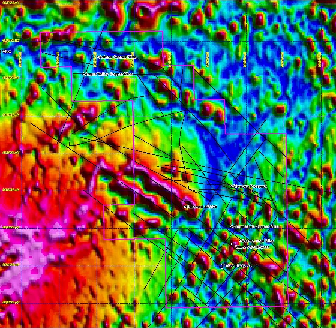
Peter Gregory’s 2016 review records that Queensland Tantalite and Queensland Gold & Minerals considered Warroo to have the characteristics of a porphyry/stockwork copper–gold system, with Commodore interpreted as part of the same system. Their observations included complex fracturing, numerous small veins and mineralised shoots, and peripheral lead–zinc with or without arsenic on the eastern side.1
The contemporary record gives this interpretation a more specific basis. Queensland Tantalite’s 2004 annual report states that Placer Dome Asia Pacific commissioned Fullagar Geophysics to define intrusive-body geometry from available geophysical data. It attributes to Fullagar an interpreted buried intrusion, a proposed connection to the Warroo and Ashton mineralising systems, and a major northwest–southeast fracture linking the two prospect groups.9
The same report describes a broad magnetic high south-southwest of Mt Bullaganang and a northwest–southeast magnetic trough on its northeastern flank, apparently beneath Warroo–Commodore. The authors interpreted the trough as a fracture system that channelled mineralising fluids. Their account of Fullagar’s work also records potassium radiometric responses along parts of the fracture corridor near known mineralisation. These observations provide specific features to compare with the present magnetic images.9
Placer Dome’s historical exploration objective. The 2004 report records an objective equivalent to 3 million ounces for Placer and states that further geological and geochemical input was required. This figure describes a historical exploration objective, not a Mineral Resource estimate or a current quantified Exploration Target for Colossus.9
Alan Day’s 2015 presentation frames Warroo as an intrusion-related gold system. Gregory’s later synthesis draws on gold, arsenic, bismuth, antimony and molybdenum geochemistry to support an association with exposed and concealed Permian intrusions. A porphyry-related copper–gold system is therefore a specific model to test within the broader intrusive mineral-system interpretation.1, 2
Copper and gold are already present
The historical assays establish that the district has concentrated both metals. Their value to the porphyry investigation is to locate mineralised structures, compare copper-to-gold variation and guide sampling towards primary sulphides.
| Hole / prospect | From–to (m) | Length (m) | Gold (g/t) | Copper (%) |
|---|---|---|---|---|
| BRC039 · Warroo | 31–37 | 6 | 38.9 | 0.040 |
| BRC091 · Warroo | 33–35 | 2 | 5.77 | 5.50 |
| DDH2 · Commodore | 46–47 | 1 | 0.07 | 4.67 |
| RWARC001 · Oxiana | 237–239 | 2 | 4.21 | 0.52 |
| RWARC002 · Oxiana | 84–85 | 1 | 0.13 | 1.64 |
Lengths are downhole intervals; true widths and mineralisation remaining after mining require determination. BRC039 includes 1 m at 120 g/t Au. BRC091 includes 1 m at 8.70% Cu and 10.1 g/t Au. Multi-metre values are historical or calculated length-weighted composites as detailed on the project page. BRC039 records 50–60% sample return at 36–37 m; BRC091 records no return from 35 m. These selected results establish local mineralisation and do not define a bulk porphyry grade or resource.
Gregory also reports minor bornite–chalcopyrite–quartz veins in the two Oxiana holes at Warroo, with locally weak sericite alteration. Bornite and chalcopyrite add a useful primary copper observation. Their importance will depend on vein abundance, cross-cutting relationships, alteration and whether their distribution strengthens towards an intrusive centre.1
Putting the mineral system together
The strongest case comes from relationships between observations. MineFinder’s working framework connects six components to practical exploration tests.
Locate the mineralising intrusion
Mt Bullaganang Granite, smaller intrusive bodies and intermediate dykes provide evidence of magmatism. Historical geophysics suggests concealed bodies. Petrography, whole-rock chemistry and age dating can identify which intrusive phase supplied the mineralising fluids.
Resolve the structural intersections
Northwest corridors through Warroo and Ti-Tree approach the intrusive setting. A northeast corridor west of Warroo includes Glenrosa. Mapping must establish which faults and fractures were open during mineralisation and where they intersect at depth.
Identify receptive rock volumes
Deformed Texas Beds contain mineralised shears, silicified zones and vein networks. Logging and sampling can test whether fluid flow and replacement extend into a substantial volume of wall rock around the higher-grade structures.
Measure the metal and alteration pattern
Copper–gold veining, Au–As–Bi–Sb–Mo geochemistry and interpreted peripheral Pb–Zn anomalism provide a possible pattern. Consistent multi-element sampling and mineralogy can test whether that pattern points towards a common centre.
Connect the geological events
Intrusion, deformation, veining and alteration must fit the same mineralising history. Cross-cutting relationships and suitable dating can distinguish one evolving system from unrelated events superimposed in the same district.
Determine what remains concealed
Covered extensions and possible buried intrusions create targets. The key is to establish whether prospective intrusive margins, roof zones or peripheral mineralisation remain preserved at drillable depths.
Evidence base: Gregory (2016) and the current Colossus interpretation. The proposed relationships and tests above are MineFinder’s exploration synthesis.1, 7
A structural framework that can focus the search
Gregory places Mt Bullaganang in an interpreted dilational hinge of the Texas Orocline and identifies northwest and northeast structural corridors across the district. This provides a hypothesis for both intrusive emplacement and later fluid movement. At the mine scale, shallow flatmake structures, steep shears and subsidiary fractures offer a framework for testing how mineralisation moved through the host rocks.1
The exploration task is to connect these scales. A regional lineament becomes a useful drill target when field relationships, alteration and geochemistry establish its role in the mineral system. Later displacement must also be resolved: the current geometry may separate parts of a formerly connected system.
Magnetic fabric, interpreted faults and known prospects
What the magnetic data show
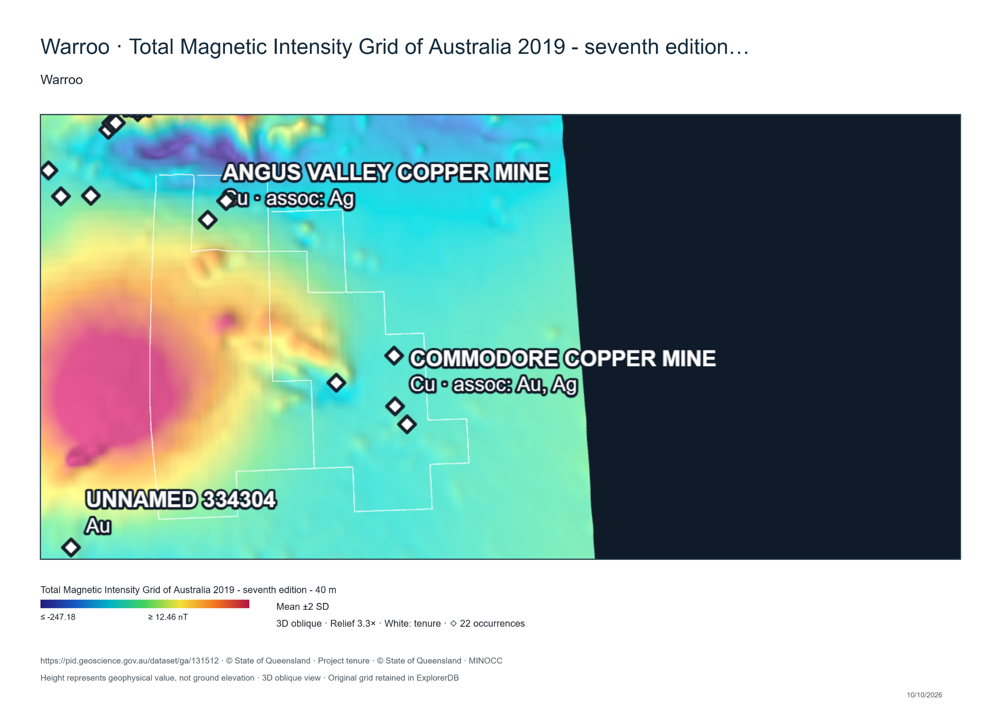
MineFinder has used Mineral Data Studio to display Geoscience Australia’s magnetic grids with the district’s recorded mineral occurrences. In the original total magnetic intensity (TMI) image, the Commodore-area occurrences occupy a comparatively subdued cyan zone beside a broad stronger anomaly. This places known mineralisation near a change in magnetic character and gives a practical focus for investigating the surrounding rocks and structures.10
The broad anomaly and nearby mineral occurrences
The reduced-to-pole first vertical derivative (RTP 1VD) displays finer magnetic variation. Several markers around Commodore and Angus Valley lie in comparatively subdued areas beside sharper features. The derivative helps trace changes that could relate to lithological boundaries, dykes or structures. It also enhances noise. Its colours represent the vertical rate of change of the magnetic field; blue does not directly identify low magnetite content.11
Local magnetic features around the known occurrences
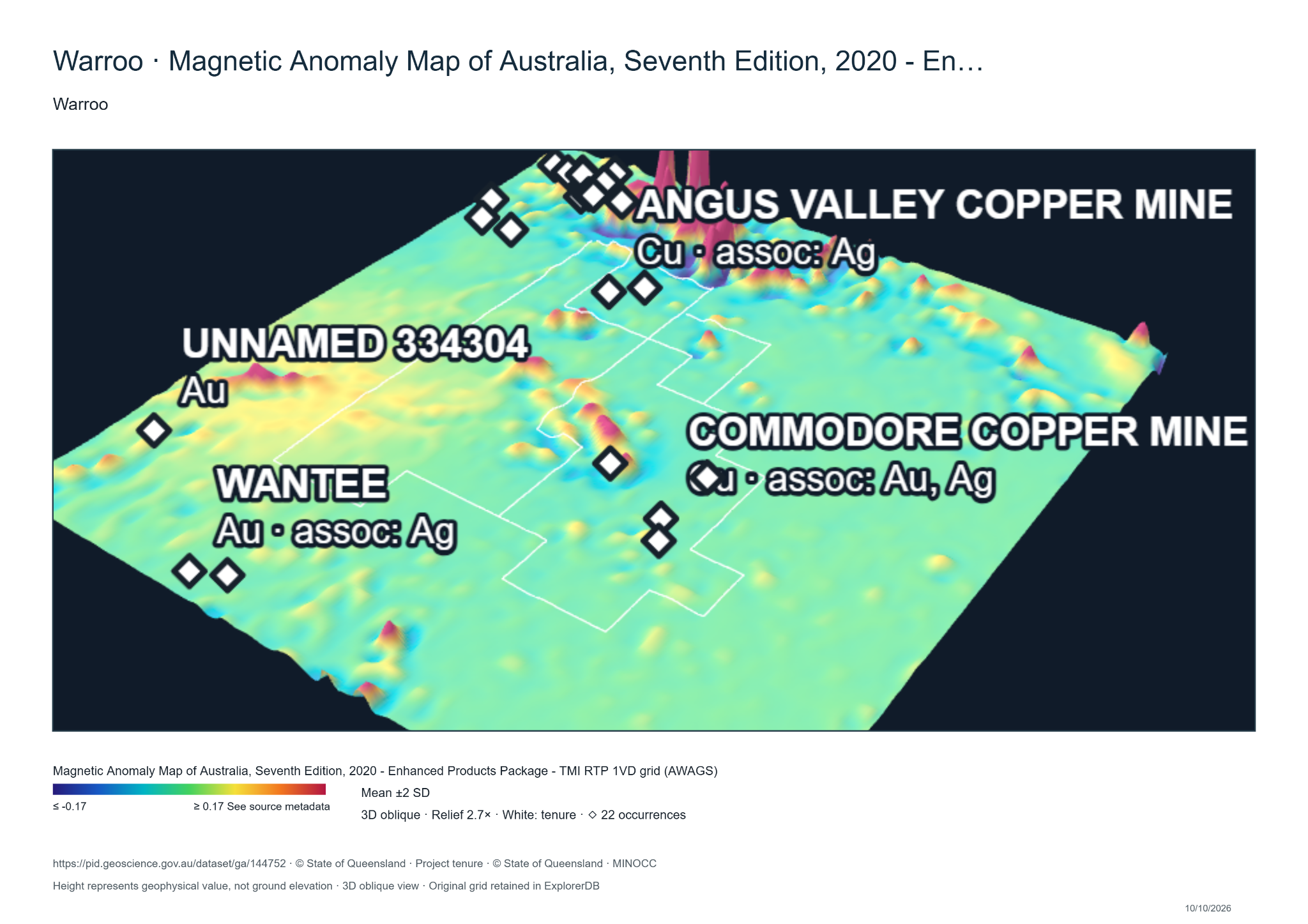
MineFinder’s working interpretation is to investigate the subdued corridor and the margins of discrete magnetic features where they coincide with mineralisation. This is broadly consistent with the historical focus on an intrusive flank and a mineralised fracture corridor. A georeferenced plan-view comparison is needed to establish whether individual features match the trough described in 2004. Priority areas are places where magnetic boundaries or structural intersections also coincide with alteration and anomalous geochemistry.
The TMI and 1VD displays are complementary views of the national magnetic data. TMI shows broader field variations; 1VD emphasises local changes. Their colour scales represent different quantities and are interpreted separately.
Follow the alteration and metal distribution
Porphyry systems form when magmatic fluids move through fractured rock, depositing sulphides and producing quartz veins and alteration. Their vein sequences, mineral assemblages and metal distribution can provide vectors towards mineralised centres. Some systems connect outward or upward to base-metal lodes and epithermal mineralisation.6
At Colossus, the interpreted copper–gold to peripheral lead–zinc relationship is a reason to map those changes systematically. The Au–As–Bi–Sb–Mo association adds evidence for intrusive influence. Neither feature fixes a deposit subtype by itself; their spatial distribution and timing will determine whether they define a porphyry-related system, an intrusion-related vein system or several separate events.
Queensland Tantalite’s fieldwork reported in 2004 provides direct observations beyond the geophysical interpretation. Mapping between Ashton and Angus Valley recorded sericitic alteration and siliceous–pyritic breccia. A small set of rock-chip samples contained gold associated with arsenic, bismuth and molybdenum. These observations support investigation of a hydrothermal system along the corridor. This fieldwork was conducted by Queensland Tantalite and is distinct from the geophysical interpretation commissioned by Placer Dome.9
Gregory’s radiometric interpretation identifies potassium-rich areas within and around Mt Bullaganang, including an arc towards Ashton. These are useful areas for field checking. Potassium response can reflect the original rock composition, weathering or hydrothermal alteration. Petrography and alteration mineralogy must establish which process explains each anomaly.
Radiometric features to test on the ground
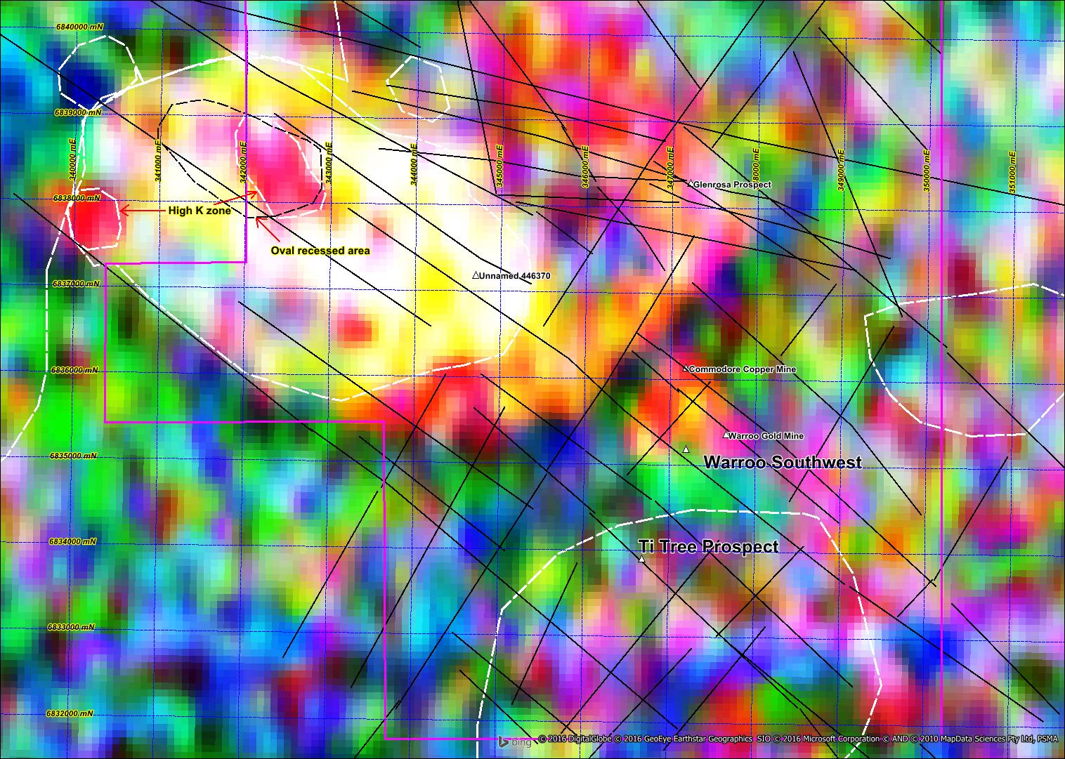
Ti-Tree adds a further question. Its quartz–carbonate vein and breccia textures have been interpreted as an epithermal expression. If it is genetically related to Warroo, it could help constrain fluid evolution and the level of the system now exposed. Establishing that connection requires matching ages, mineralogy and structural relationships.1, 2
The USGS molybdenum porphyry near Stanthorpe
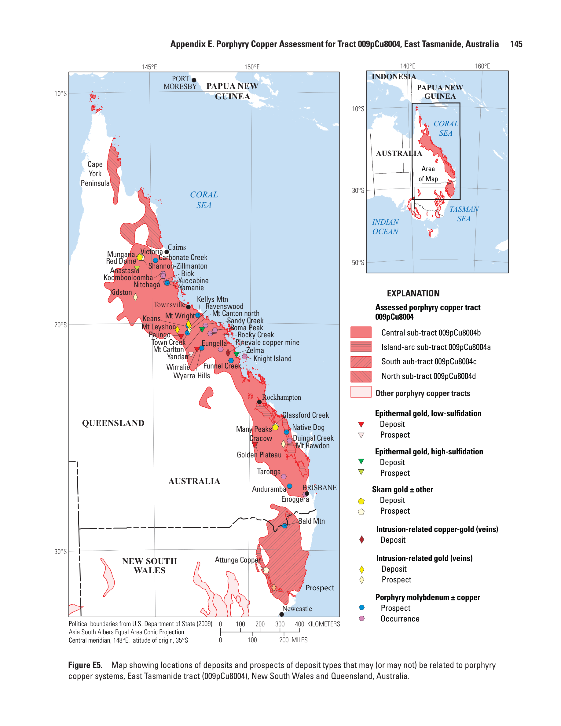
The USGS reference is identifiable: Bald Mountain, listed as “Bald Mtn” in the 2014 Porphyry Copper Assessment of Eastern Australia. Table E4B places it at 28.902°S, 151.876°E, south of Stanthorpe, and classifies it as low-fluorine porphyry molybdenum, with a listed age of 250 million years and Horton (1978) as its source. Figure E5 uses the porphyry molybdenum ± copper prospect symbol.5
Its rank 8 classification means the USGS considered it a type that may be indirectly associated with a porphyry copper system. That is valuable regional context: porphyry-style molybdenum mineralisation is documented in the wider Stanthorpe setting. It supports examination of regional magmatic and hydrothermal fertility.
The relevance to Colossus is a research direction. Comparing intrusive ages, composition and alteration can establish whether Bald Mountain and the Warroo district record related magmatic processes. The USGS classification does not establish a shared intrusion, a continuous mineralised belt or a copper–gold porphyry at Colossus.
Bald Mountain in the published porphyry framework
The tests that will make the case stronger
A major exploration partner will ask whether the observations lead to a sizeable, preserved and testable target. Three questions are decisive.
Which intrusion was fertile? Gregory describes mapped S-type granite as well as smaller, compositionally varied intrusive bodies and intermediate dykes. The exposed granite cannot simply be assumed to be the copper–gold source. Intrusive chemistry, oxidation state, alteration and geochronology need to identify the relevant phase and test the concealed-body interpretation.
What caused the geophysical response? Oxiana’s Warroo and Warroo Southwest holes showed that weakly pyritic black shale could explain several chargeability anomalies. This is a useful targeting constraint. The next model must distinguish sedimentary pyrite from mineralised vein networks, using geology, sulphide mineralogy, geochemistry and physical properties alongside geophysics.1, 4
Is the prospective level preserved? The USGS assessment flags deep erosion as a major limitation in its South sub-tract. Colossus therefore needs local evidence for preservation: intrusive contact geometry, cover, alteration depth indicators and the significance of Ti-Tree’s possible epithermal expression. This question will help determine whether to target a concealed centre, its margins or structurally focused peripheral mineralisation.5
A mixed drilling programme to test source and scale
Pre-listing MAGMA work will refine the geological models, targets and drilling design. Major drilling is planned from Q2 2027 after the proposed Canadian TSXV CPC listing and associated financing, subject to access, approvals and contractor availability.
The principal question is whether gold–copper mineralisation beneath and beyond the historical workings forms part of a larger system with sufficient grade and scale to justify further drilling. Intrusion-related gold and porphyry copper–gold are working interpretations to assess through the new results.
No historical core or usable samples survive. MineFinder therefore proposes a combination of reverse-circulation (RC) drilling and selected diamond holes. RC drilling will test mineralised widths, grades and continuity across several targets. Diamond drilling will preserve the vein, sulphide, alteration and structural relationships needed to assess the geological model and guide exploration towards a possible larger mineralised centre.
Prepare the geological tests
Integrate historical collars, surveys, assays, logs and mine plans in sections and a three-dimensional model. Revisit the Fullagar interpretation and select targets where structure, alteration, geochemistry and a credible intrusive model coincide. Define the question for each hole before drilling.
Combine RC coverage with diamond core
Initial targets are Warroo, Warroo Southwest and the Warroo–Commodore corridor. RC drilling will test extensions across several positions. Selected diamond holes will cross representative mineralisation and surrounding alteration. Initial diamond results will inform the remaining drilling.
Analyse the mineralisation and its geological setting
Photograph and log core for lithology, vein density, cross-cutting relationships, sulphides and alteration; orient core where ground conditions permit. Use gold and multi-element assays with blanks, certified reference materials and duplicates. Selected polished thin sections will assess whether gold and copper belong to the same mineralising stage. Fluid-inclusion studies will follow where suitable quartz is present and the results can help distinguish the interpretations.
| Component | Holes | Metres | Purpose |
|---|---|---|---|
| RC drilling | 8–12 | 1,200–1,800 | Test mineralised widths, grades and continuity |
| Diamond holes | 2 | 400–600 combined | Recover intact mineralisation and surrounding alteration |
| Total | 10–14 | 1,600–2,400 | Assess extensions and guide the next exploration stage |
These quantities are preliminary design assumptions. Final collars, depths and the drilling mix will follow review of historical sections, access and contractor quotations. Diamond holes may use RC pre-collars where suitable; core must begin above the intervals needed for interpretation. Pre-collar metres are included within the total programme.
Budget and timing. The mixed programme budget will cover drilling, assays, geological studies, access, rehabilitation and contingency. Quantities will be adjusted to confirmed costs. Mobilisation depends on funding, access agreements, approvals and contractor availability; the schedule will follow drilling and laboratory quotations.
What the results will establish. Mineralised extensions and coherent alteration and metal patterns would support further exploration. Narrow isolated veins without a broader mineralised envelope would weaken the scale case. A missed target or poor recovery must be assessed before drawing a geological conclusion. The integrated results will assess continuity, compare the geological interpretations and prioritise follow-up targets.
The wider Glenrosa, Ashton–Angus Valley and Ti-Tree centres provide further opportunities to test whether the mineral system repeats across the district. View the Colossus drilling programme.7
An opportunity for a major exploration partner
Colossus offers a mineralised district, a substantial historical evidence base and a source question that can be tested. Its appeal is the combination: demonstrated copper and gold, multiple mineralised centres, intrusive activity, structural complexity and specific opportunities to investigate concealed extensions.
A successful programme would establish a fertile intrusive phase, a coherent alteration and metal pattern, preserved target geometry and a larger volume of primary mineralisation. Those results would materially strengthen the case for sustained district exploration.
MineFinder’s proposition is clear: use a mineral systems approach to determine whether the historical Warroo workings sit within a larger porphyry-related copper–gold system. The opportunity is to discover how much of that system remains beyond the workings—and where its most prospective parts are preserved.
Explore the Colossus project, historical results and proposed programme →
Sources and technical basis
- Gregory, P. (2016) — Brief Review of Exploration Potential of EPM 26178, Warroo
GeoDiscovery Group, 6 July 2016. Historical exploration synthesis and interpretation of geology, structure, magnetics, radiometrics and gravity. Figures 6 and 9 reproduced below. The Placer–Fullagar discussion also draws directly on the 2004 annual report, listed as source 9.
- Day, A. (2015) — Warroo Cu–Au Prospect: An Intrusive Related Gold System
June 2015 presentation. The Warroo section provides historical exploration and intrusive-system context. Its separate Crystal Mount section is not evidence for Colossus.
- Historical Warroo drill-hole compilation (2022)
QMines historical data compilation: DH_Assays, collars, geology and surveys. Selected intervals are consistent with the existing Colossus project table. Original report references include CR18894, CR21233 and CR49512.
- Burdett, M. N. (2007) — Oxiana Warroo annual report, CR49512
EPM 13831, year 4 to 13 May 2007. Tables 2–3 support the RWARC001 and RWARC002 intervals. Geological observations and programme interpretation are also summarised by Gregory (2016).
- Bookstrom and colleagues (2014) — Porphyry Copper Assessment of Eastern Australia
USGS Scientific Investigations Report 2010–5090–L, prepared with the Geological Survey of NSW and Geoscience Australia. Table E4B, printed p. 144: Bald Mtn, 28.902°S, 151.876°E, listed age 250 Ma, low-fluorine porphyry Mo, rank 8, citing Horton (1978). Figure E5, p. 145: porphyry molybdenum ± copper prospect symbol. Table 2 explains rank 8. The South sub-tract discussion addresses erosion and preservation.
- Dilles, J. H. & John, D. A. (2021) — Porphyry and epithermal mineral deposits
General mineral-system framework: magmatic fluids, vein formation, alteration and possible relationships between porphyry, base-metal lode and epithermal environments.
- MineFinder — Colossus project and evidence
Company project interpretation, district dimensions, historical results, sampling notes and proposed work. The approximately 2 km and 15 km dimensions describe interpreted exploration footprints.
- Historical Warroo flatmake sampling quotation
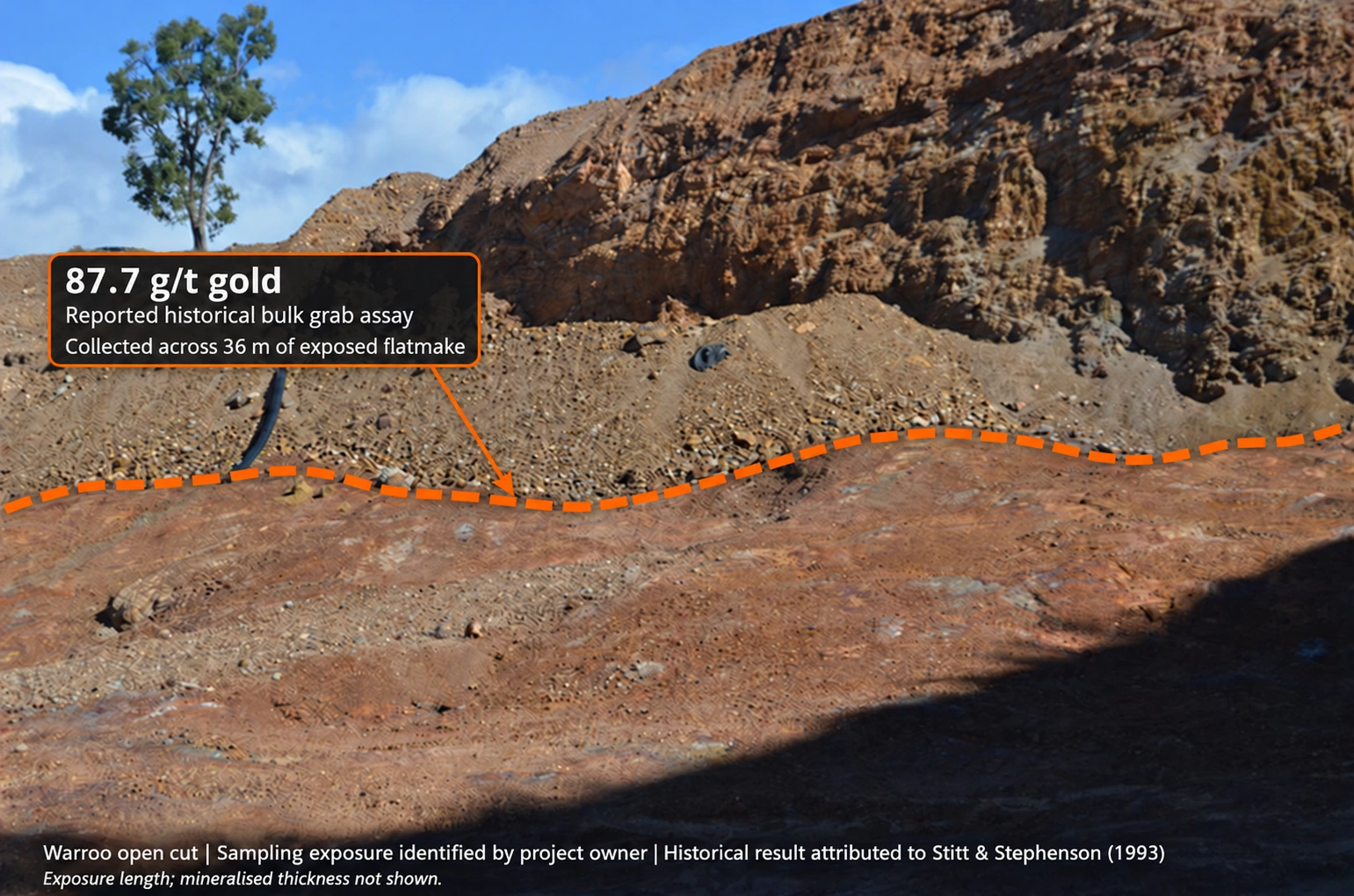
Warwick Anderson reproduces wording attributed to Stitt & Stephenson (1993): a bulk random grab assay of 87.7 g/t Au from material collected across 36 m of exposure. Original report and assay documentation remain to be located; see the project sampling notes.
- Day, A. & Nethery, J. (2004) — EPM 13831 (Warroo), annual report, CR37565
Queensland Tantalite Pty Ltd, September 2004; reporting period 14 May 2003 to 13 May 2004. Page 7, sections 3.4–3.5: regional magnetic trough, Placer-commissioned Fullagar interpretation, potassium radiometrics and historical 3 million ounce exploration objective. Pages 10–11: Queensland Tantalite mapping, alteration, breccia and rock-chip geochemistry. The Fullagar conclusions are attributed through this contemporary report.
- Geoscience Australia — Total Magnetic Intensity Grid of Australia 2019, seventh edition, 40 m
Source grid identified in the Mineral Data Studio TMI export. Visualisation by Warwick Anderson, 10 October 2026; Queensland Government occurrence and tenure overlays. The original 2048 × 1447 export is reproduced in full. Vertical relief represents the magnetic value.
- Geoscience Australia — Magnetic Anomaly Map of Australia 2020, TMI RTP 1VD
Official metadata describes the first vertical derivative calculated from the variable reduced-to-pole national magnetic grid. The Mineral Data Studio export identifies the associated TMI RTP 1VD grid as GA 144752. First vertical derivatives enhance shorter-wavelength detail and noise. Visualisation by Warwick Anderson, 10 October 2026.