
SILVERWOOD · STRUCTURE & MINERAL SYSTEMS
The Demon Fault: reconstructing Silverwood’s mineral systems
Regional structure. Separate geological events. More focused questions for copper–gold exploration.
The Silverwood exploration opportunity extends beyond individual workings and drill intersections. Regional structure can help explain how intrusive rocks, fluid pathways and mineralised zones fit together. The Demon Fault adds a significant geological question to that assessment.
Published research links the fault to displacement of rocks correlated with the Silverwood Block. For MineFinder, the opportunity is to use that history to improve the geological models behind Vulcan and Lucky Valley.2
Our mineral systems approach examines the processes needed to form and preserve a deposit: metal and heat sources, fluid pathways, suitable host rocks, mineral deposition, timing and preservation. Structural reconstruction is one part of that process. It helps turn regional geology into questions that can be tested on the ground.
A major structure in the New England Orogen
The Demon Fault extends approximately 200–215 kilometres through northeastern New South Wales. It trends broadly north–south. Its main movement was dextral, or right-lateral, with a smaller reverse component. The combined movement records lateral displacement and compression.1
Structural research identifies four principal segments. Estimated horizontal offsets range from approximately 19 to 35 kilometres. Several branches occur at the northern end, where differently oriented faults were interpreted as a northward-propagating damage zone. The fault system also displaces older structures and Triassic intrusive rocks.1
For exploration, this geometry makes reconstruction important. Rocks that now appear separated may once have been closer together. A present-day contact or structural intersection must therefore be assessed in the context of the events that created it.
The published Silverwood connection
A 2021 study identifies the Willowie Creek beds in northern NSW as a possible continuation of the Silverwood Block. These rocks lie approximately 120 kilometres southeast of the Queensland Silverwood section examined in that study. The authors interpret approximately 25 kilometres of dextral displacement across the Demon Fault.2
This gives MineFinder a published basis for considering Silverwood within a wider structural framework. Correlation of the separated rock packages can inform regional reconstruction and the search for comparable geological settings.
The northern endpoint needs separate assessment. The original 1978 study described the fault dying out within plutons of the Stanthorpe Plutonic Suite, with no recognised extension into southern Queensland. That is the historical mapping interpretation. A direct continuation to the Warwick–Vulcan ground remains a geological question to test.4
The regional relationship is shown in Figure 2 of the 2021 Silverwood study. The individual fault segments are mapped in Figure 2 of the 2013 Demon Fault study.
Timing determines the exploration meaning
A 2019 study dated clay minerals in fault gouge from the northern Demon Fault using three isotope systems. The principal results cluster at approximately 163–152 million years, establishing Late Jurassic movement. The fault displaces Triassic granitoids with reported ages of approximately 249–232 million years.3
- LATE DEVONIAN
Silverwood succession
Deposition of the Silverwood rocks investigated in the 2021 study. [2]
- TRIASSIC · 249–232 Ma
Regional intrusive rocks
Reported ages of granitoids subsequently displaced by the Demon Fault. [3]
- LATE JURASSIC · 163–152 Ma
Dated fault movement
Fault-gouge ages establish a younger deformation episode. [3]
This age relationship is central to the porphyry question. The dated fault movement occurred after the Triassic intrusions. These results establish a deformation episode; they do not resolve every possible earlier phase of structural development.3
Our exploration interpretation is that older structures may have influenced intrusive emplacement or fluid flow, then undergone later displacement. Establishing that sequence requires evidence from rock contacts, vein relationships, mineral textures and suitable age dating. A fault’s length alone does not establish its role as a mineralising pathway.
From regional structure to project targets
For Vulcan and Lucky Valley, we see three useful lines of investigation. Each connects a regional observation to a practical targeting question.
Find the structures active during intrusion
Compare intrusive contacts, dykes, veins and faults. Establish which structures existed when magma and mineralising fluids moved through the rocks.
Reconstruct separated parts of the system
Test whether fault movement separated matching rock contacts, alteration zones or mineralised structures. Use those relationships to guide the search for extensions.
Assess what remains beneath cover
Integrate structural interpretation with geology and geophysics. Determine where prospective intrusive contacts and host rocks could remain concealed.
At Vulcan, this work supports assessment of the documented porphyry copper–gold hypothesis alongside the established sulphide occurrences. The project page sets out the evidence and proposed tests for intrusive sources, alteration, fluid pathways and timing.
At Lucky Valley, the same approach can help assess the relationship between gold-bearing veins, intrusive contacts and the possible bedrock sources of historical alluvial gold. Each project requires its own local structural evidence.
The project district in its magnetic setting
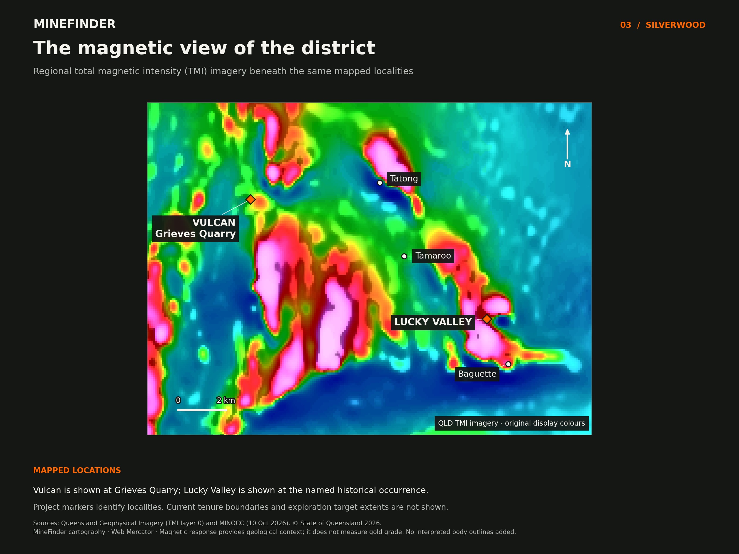
The wider granite and alteration setting
A separate 2019 study integrated magnetic, gravity and radiometric data across the Stanthorpe region. It interpreted a faulted belt of weak magnetic response within the Stanthorpe Granite as hydrothermally altered rock. The study also discusses regional molybdenum, tungsten, bismuth and tin occurrences associated with quartz stockworks and greisen alteration.5
These observations add context to the district’s intrusive mineral potential. Their relevance to an individual copper–gold target depends on intrusive composition, age, alteration and metal distribution. MineFinder’s interpretation is that these features should be assessed together to distinguish mineral systems and identify the most useful follow-up work.
A stronger basis for targeting
The Demon Fault research provides a reason to examine the regional geological history in greater detail. The immediate structural task is to compare published fault traces and branches with Silverwood boundaries, intrusive contacts, alteration and the current project areas. That comparison can identify where field observations will most improve the model.
The exploration opportunity is to recover the relationships between parts of the mineral system. For MineFinder, success means clearer target geometry, a better understanding of preservation and more focused tests of the copper–gold and gold opportunities at Vulcan and Lucky Valley.
Sources and further reading
- Babaahmadi & Rosenbaum (2013) — Kinematics of the Demon Fault: Implications for Mesozoic strike-slip faulting in eastern Australia
Australian Journal of Earth Sciences 60, 255–269. Fault geometry, segment displacement, northern branches and relationships to Triassic rocks. Figure 2 shows the regional fault segments.
- Rosenbaum and colleagues (2021) — Origin of the Intra-Oceanic Silverwood Block
Tectonics 40, e2021TC006920. Silverwood geology and the proposed correlation with the Willowie Creek beds. Figure 2 shows the regional structural interpretation.
- Babaahmadi, Uysal & Rosenbaum (2019) — Late Jurassic intraplate faulting in eastern Australia: A link to subduction in eastern Gondwana and plate tectonic reorganisation
Gondwana Research 66, 1–12; published online in 2018. Fault-gouge dating establishes Late Jurassic movement on the northern Demon Fault.
- Korsch, Archer & McConachy (1978) — The Demon Fault
Journal and Proceedings of the Royal Society of New South Wales 111, 101–106. Historical description of the northern termination. Link opens the digitised collected volumes.
- Kumwenda & Lackie (2019) — Geophysical interpretation of the geology of the Stanthorpe region using aeromagnetic, gravity and radiometric data
Exploration Geophysics 50, 653–666. Integrated geophysical interpretation of granites, structures and hydrothermal alteration in the Stanthorpe region.