
SILVERWOOD · GOLD & COPPER EXPLORATION
Silverwood: the Mount Morgan connection and MineFinder’s gold opportunity
An extraordinary mining history. A published geological connection. Two MineFinder projects with new opportunities to test.
Mount Morgan became one of Australia’s great mineral discoveries and, in the early 1900s, the world’s largest gold mine. Today, its extraordinary history provides a powerful reason to look closely at geologically related ground in Queensland’s Silverwood terrane—where MineFinder is advancing the Vulcan and Lucky Valley exploration opportunities.1
The attraction is substantial: a published geological relationship to Mount Morgan’s host province, established mineral occurrences, historical workings and specific questions that modern exploration can answer. At Vulcan, we are investigating gold potential within a known base-metal sulphide system. At Lucky Valley, we are assessing whether gold-bearing veins, breccias and old workings point towards a larger intrusion-related system.
These are two distinct projects with a shared regional context. Together, they give MineFinder the opportunity to bring fresh geological thinking to ground with a long history of mineral discovery.
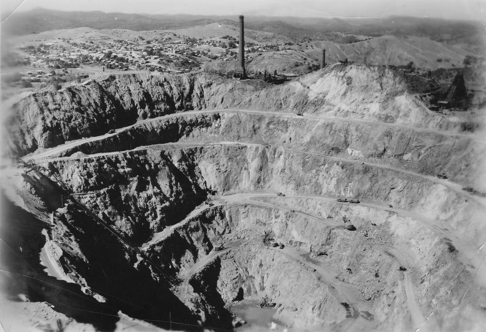

Mount Morgan: a discovery that changed Queensland
Mining began at Mount Morgan in 1882. Its early success came from exceptionally rich oxidised ore at the surface: the Queensland Government records approximately 2.44 million tonnes of gossan averaging 29.5 grams of gold per tonne. This weathered cap alone yielded almost 72 tonnes of gold.2
The mine developed into a major gold and copper operation. The same government account records approximately 250 tonnes of gold—about eight million troy ounces—and 360,616 tonnes of copper from more than 50 million tonnes of ore. Those figures place Mount Morgan among the defining mineral deposits in Queensland’s history.2
The original syndicate included the Morgan brothers, William Knox D’Arcy and members of the Hall family. Their discovery helped build fortunes with influence far beyond the district. D’Arcy’s Mount Morgan wealth helped finance the Persian oil venture that ultimately led to BP, while the Hall family’s legacy extended into major philanthropy and medical research.3
Mount Morgan’s operating history also records repeated reinvention. Early underground mining gave way to open-cut development after the difficulties of the late 1920s. Mining continued until 1981, followed by treatment of historical tailings from 1982 to 1990. Different generations extracted value from different parts of the same remarkable mineral system.3
For MineFinder, the lasting significance is geological. Understanding the rocks, structures and mineralising processes around a major deposit can sharpen the search for new opportunities in related settings.
The Silverwood terrane: an ancient volcanic and sedimentary setting
Silverwood is a geological block within the New England Orogen of eastern Australia. Its rocks record submarine volcanism, sedimentation and subsequent deformation. The succession includes basaltic volcanic rocks, volcaniclastic sediments, sandstone, mudstone, chert and limestone-bearing units—a varied geological setting in which several styles of mineralisation can be investigated.4
The term terrane describes a body of rocks with a recognisable geological history. Silverwood is also described as a block or province in the literature; the Silverwood Group is a rock succession within that setting.
Recent research has materially improved the geological picture. A 2021 study used microscopic fossils and zircon ages to show that the Silverwood rocks it investigated were deposited in the Late Devonian, later than some older interpretations suggested. Older fossils and mineral grains can occur as recycled material within younger sediments. The study also identified geochemical evidence for an oceanic arc-related source.4
This evolving understanding matters to exploration. Reassessing the age and origin of the host rocks can change how individual prospects are connected, which structures are important and which mineralisation models deserve testing.
The geological connection to Mount Morgan
Mount Morgan lies within the Calliope Province, in its Capella Subprovince. Silverwood is a separate mapped geological block. The connection is a published correlation between these arc-related terranes within the New England Orogen.5
A 2026 study by Gomes and colleagues provides further support for the interpretation that Calliope, Silverwood and Gamilaroi may represent segments of the same ancient arc system. Comparable Devonian mineral ages and evidence of recycled older material strengthen that relationship. The study also argues that the Calliope arc developed on strongly extended continental crust, explaining its mixture of oceanic and continental characteristics.5
That is a significant regional connection for MineFinder. It places our Silverwood exploration within a geological discussion that includes the province hosting one of Australia’s outstanding gold–copper deposits. The relationship supplies a regional exploration rationale; the size and grade of any discovery at Vulcan or Lucky Valley will be established by results on those projects.
Silverwood, Calliope and the Mount Morgan setting
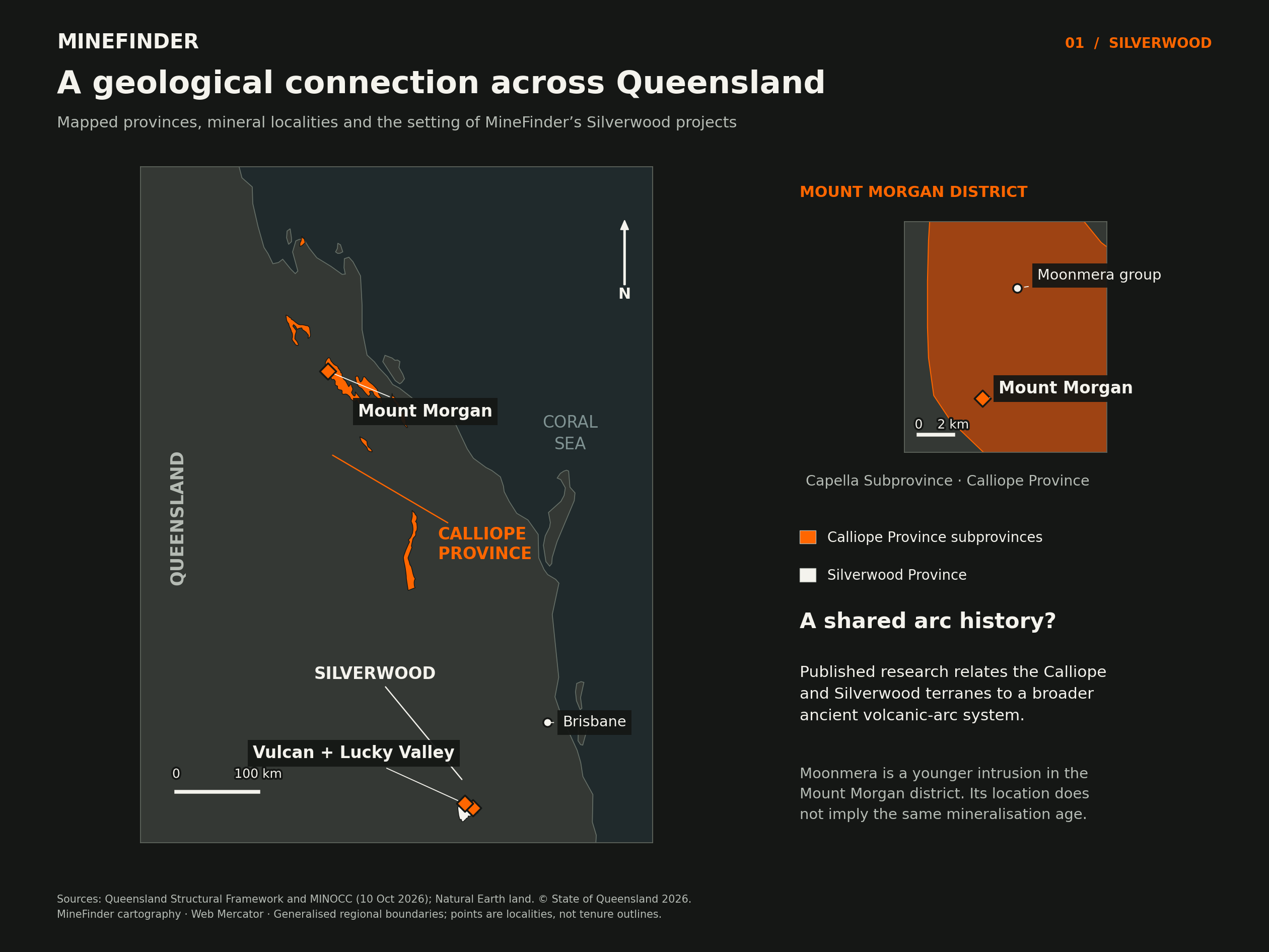
Why this setting deserves a fresh exploration focus
Mount Morgan also demonstrates why a mineral system deserves to be examined from more than one geological perspective. Its ore occurs in a volcanic and sedimentary rock package enclosed by intrusive rocks. Published interpretations have included volcanic-hosted massive sulphide mineralisation and replacement processes associated with intrusion, with debate over the relationship and timing of gold and copper.6
MineFinder is applying that questioning approach to Silverwood. Our working models examine where metal-bearing fluids could have travelled, which rocks could have reacted with them and whether later intrusive activity introduced or redistributed mineralisation. Volcanic units, limestone contacts, breccias and faults each provide features to map and test.
The practical opportunity is to connect observations that earlier exploration may have considered separately. A copper intersection, a magnetic feature, a quartz vein and an old gold working become more useful when their positions and geological relationships can be assessed together.
We are particularly interested in places where several observations coincide: sulphides near a reactive contact, gold-bearing veins close to an intrusion, or structures cutting through both. These combinations help turn a broad regional concept into a focused exploration target.
Vulcan: a known sulphide system with gold potential to test
Vulcan offers a direct starting point. Historical Geological Survey of Queensland drilling at Grieves Quarry is reported to have intersected 27.2 metres at 0.7% copper, including 12.3 metres at 1.2% copper. The shorter, higher-grade interval is contained within the wider intersection; these are reported drill lengths.7
Historical work identified zinc, copper, lead and silver sulphides. The project record also describes electromagnetic and induced-polarisation responses associated with the sulphide zones. This gives Vulcan an existing base of drilling and geophysical information from which to develop the next geological tests.7
The gold question is especially attractive. Gold was not systematically tested in the earlier work described by the company. MineFinder’s revised model considers whether a later intrusive event could have introduced a gold component into the volcanic–carbonate setting.
Our immediate priority is to review available historical core and assay suitable material for gold. Relogging can examine the relationships between sulphides, veins, alteration and host rocks; the assays can then establish whether gold accompanies particular features. That combination can guide both the interpretation and the selection of any follow-up drilling.
This is a focused opportunity to extract more information from an existing exploration investment. If gold is identified, its geological position will help us assess where the system should be tested next. The same review can improve our understanding of the copper-bearing sulphides and the potential for extensions along strike or down dip.
The Mount Morgan connection gives this work a broader geological context. Vulcan’s own core, assays and field relationships will determine which parts of the model hold together.
Vulcan and Lucky Valley in their bedrock setting
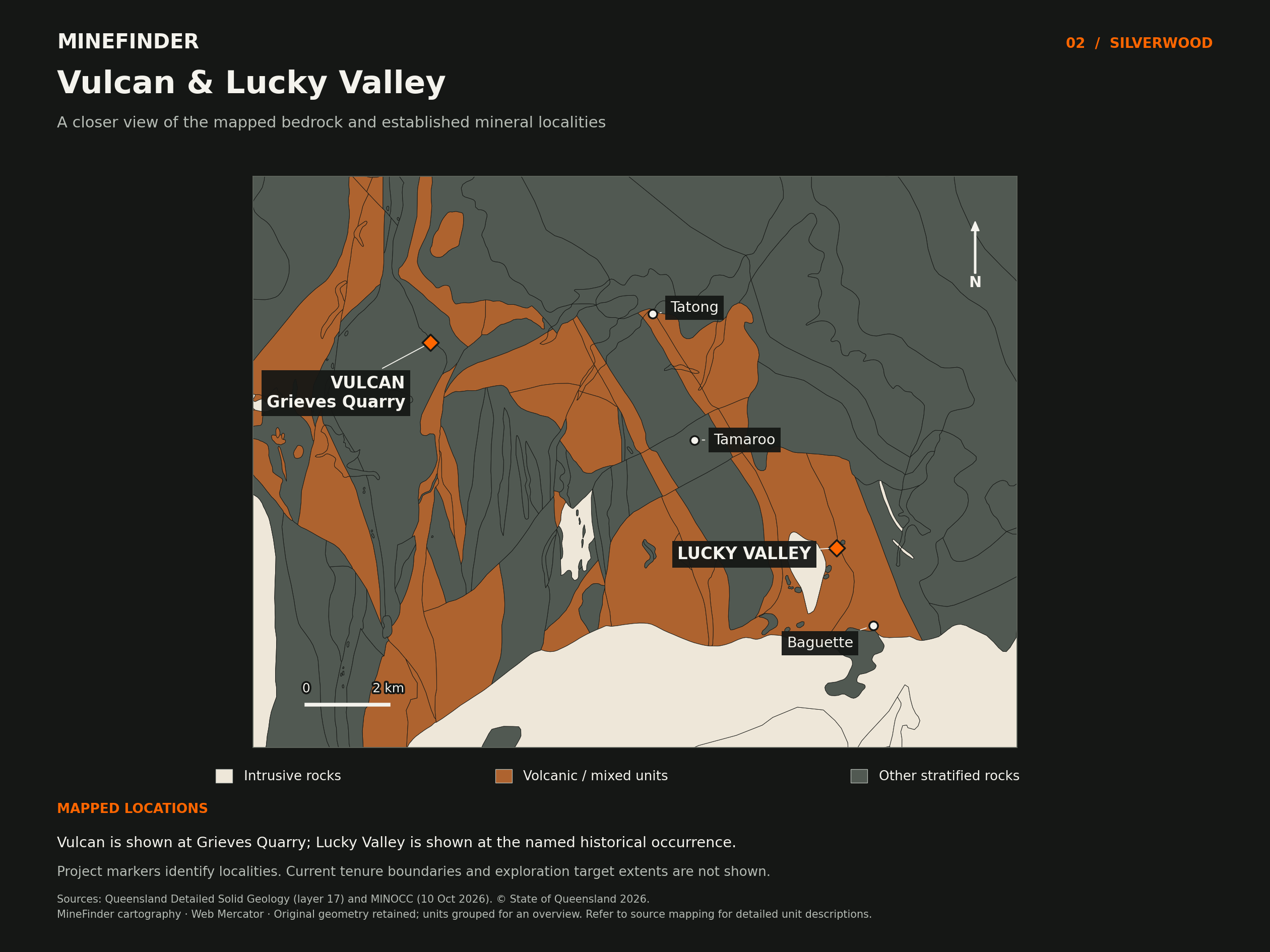
Lucky Valley: following gold towards its source
Lucky Valley presents a complementary gold opportunity south-east of Warwick. Historical workings and surface sampling identify mineralisation associated with diorite intrusions, quartz veins, breccias and limestone within the Silverwood Group.8
A 2013 geological review compiled historical surface assays of up to 14.3 g/t gold at Baguette, 4.3 g/t at Aspinalls, 1.5 g/t at Tamaroo and 1.3 g/t at Lucky Valley. These are individual historical surface results from different prospects and sample settings. They give us specific locations and geological associations to investigate.8
The same review interpreted an approximately 11-kilometre geological corridor between Baguette and Tatong, linking magnetic features, intrusive rocks and scattered mineral occurrences. That length describes a district-scale geological trend, rather than a measured continuous gold zone or MineFinder’s tenure footprint.8
Our central question is whether the known gold occurrences are expressions of a larger intrusive system. Diorite contacts, broken rock zones and reactive limestone offer different places in which mineralisation may have developed. Their intersections with faults and veins provide a practical framework for targeting.
A magnetic perspective on the project district
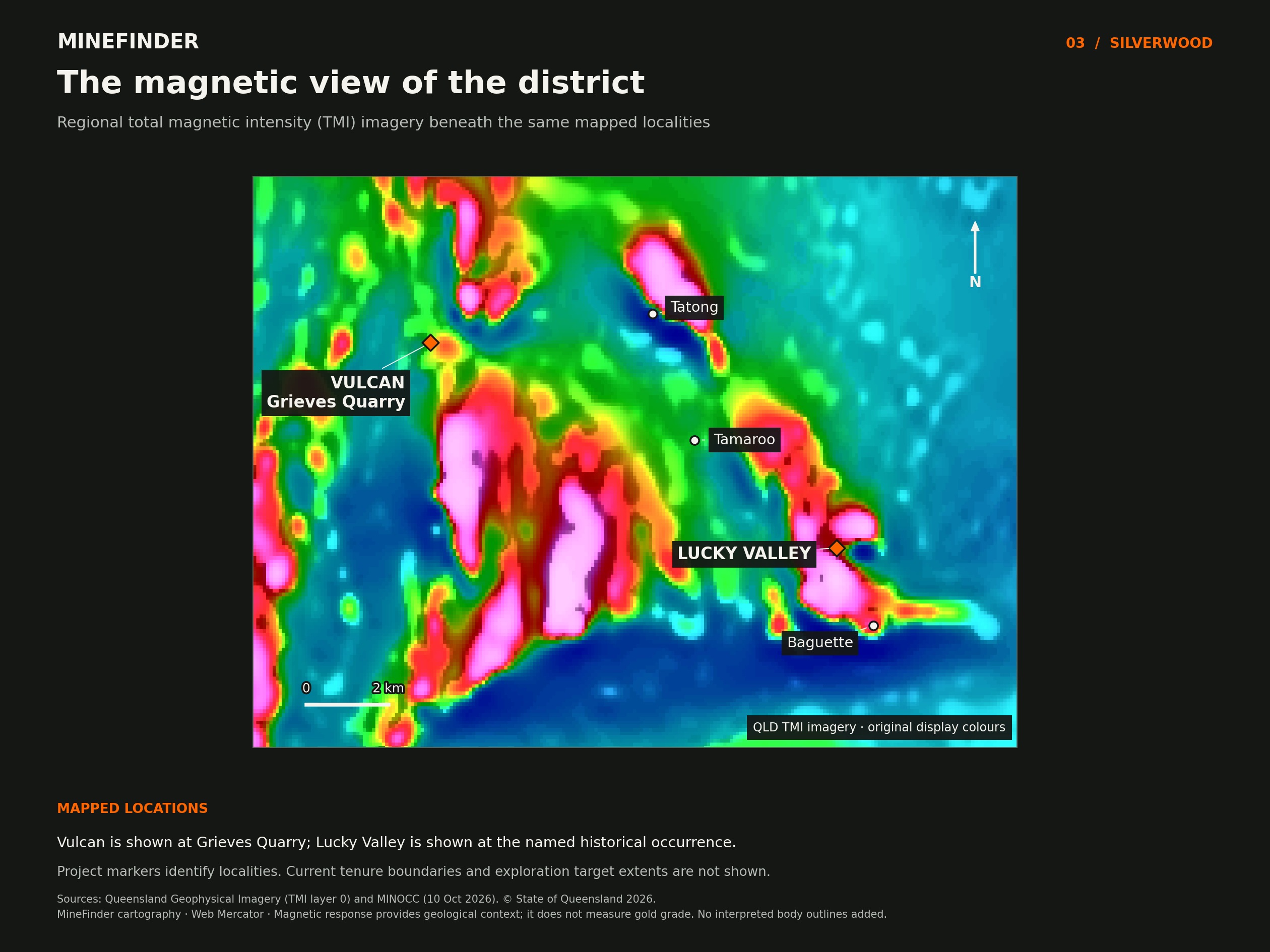
Modern terrain data adds another useful perspective. MineFinder’s LiDAR interpretation highlights the distribution of historical alluvial workings and a possible source area on the south-western hill. This interpretation creates a clear field question: can gold in the drainage be traced back to mineralised bedrock in that area?
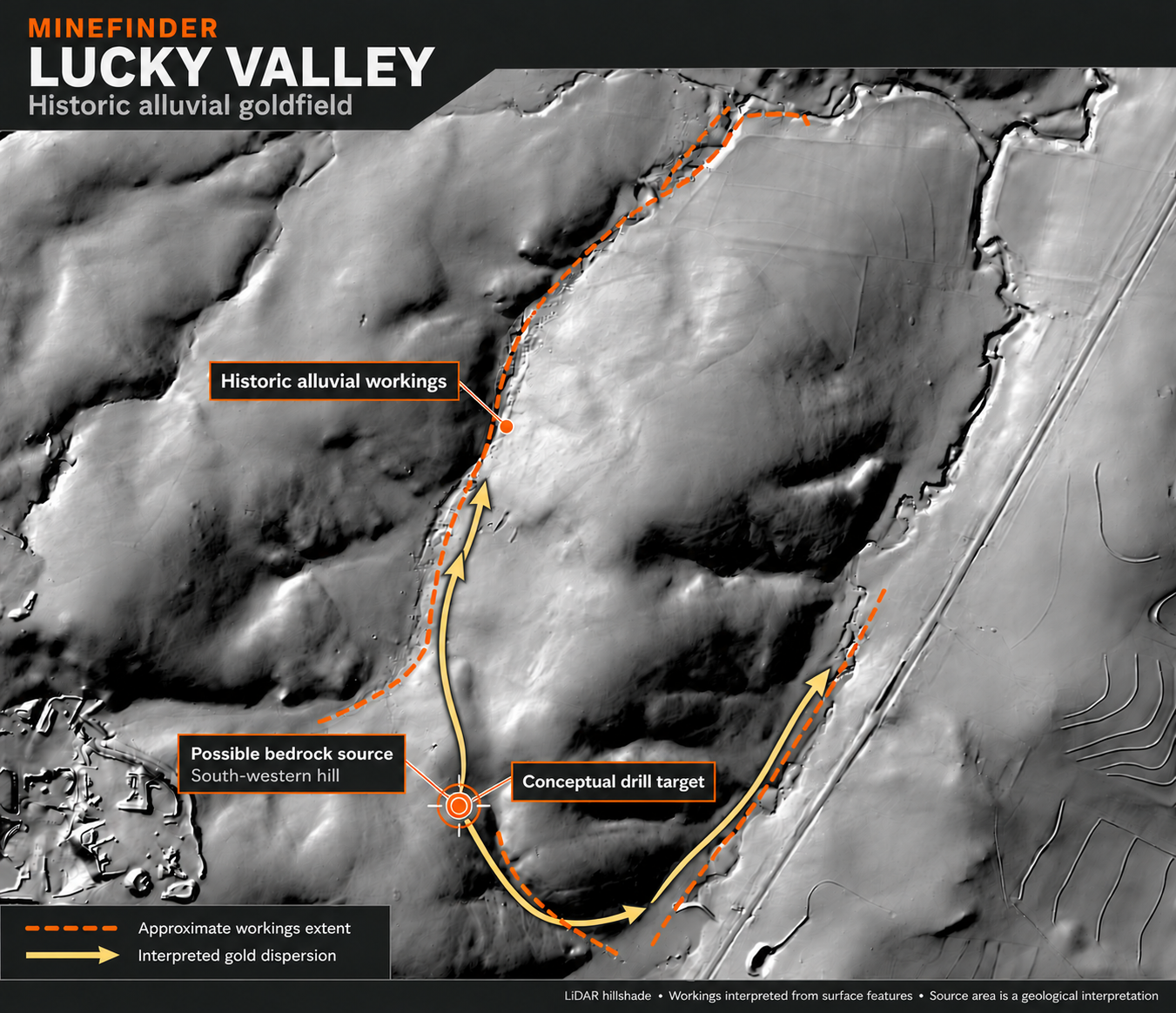
The next work brings these observations together: locate historical samples and workings accurately, map intrusive contacts and structures, collect representative gold and multi-element samples, and compare the results with magnetic and terrain data. This will help distinguish individual veins from broader zones of alteration or mineralisation.
Lucky Valley’s appeal is the combination of known gold occurrences and a larger geological question that remains open. MineFinder is developing it as a separate project, with its own targets and exploration pathway.
Explore the Lucky Valley project →
Moonmera: evidence of a younger mineralising episode
The Moonmera copper–molybdenum porphyry prospect near Mount Morgan adds another dimension to the regional story. The US Geological Survey records alteration ages of approximately 252–251 million years. That is much younger than the approximately 380-million-year-old Mount Morgan intrusion described in the geological literature.9, 5
Moonmera therefore belongs in the discussion as evidence of a separate, younger intrusive mineralising episode in the broader district. It should not be treated as a coeval part of the Devonian Mount Morgan system. For MineFinder, the useful exploration question is whether successive events have left distinguishable mineralisation at our own projects—a question that mapping, petrography, assays and, where needed, age dating can address.
The Demon Fault and Silverwood’s structural history
Our companion article examines the published connection between the Demon Fault and Silverwood-correlated rocks, the timing of fault movement, and the questions this raises for exploration at Vulcan and Lucky Valley. It includes a geological timeline, district magnetic map and links to the primary research.
The Demon Fault: reconstructing Silverwood’s mineral systems →
Building the next chapter of exploration at Silverwood
Silverwood brings together a compelling set of ingredients: a geological relationship to the Calliope arc, a district with historical gold and base-metal occurrences, and projects with identifiable work to do next. Mount Morgan supplies the historical scale of what this broader geological setting has produced. Vulcan and Lucky Valley supply the project-specific opportunities.
At Vulcan, the immediate opportunity is to test a new gold interpretation using available core and targeted assays. At Lucky Valley, it is to connect known gold occurrences with their bedrock controls and assess the potential for a larger intrusive system. Both programmes are designed to produce information that can materially improve target selection.
MineFinder’s approach combines historical records with modern geological interpretation, terrain data and integrated exploration software. We aim to make the accumulated information work harder: clarify what previous exploration established, identify the questions it left open and design the next programme around the most promising targets.
The opportunity is to bring a fresh exploration focus to a mineralised district with a remarkable geological connection. Vulcan and Lucky Valley are where MineFinder is putting that opportunity to work.
Sources and further reading
- Queensland Government — New tech turning old gold mine into future jobs (23 November 2022)
Official description of Mount Morgan as the world’s largest gold mine in the early 1900s.
- Queensland Government — Mount Morgan No 7 Dam reserve: geology and mining history
Historical production, oxide-gold grades and geological setting.
- Rockhampton Regional Council — Advancing Mount Morgan Strategy (2019)
Mine development, company history and the transition from mining to tailings treatment.
- Rosenbaum and colleagues (2021) — Origin of the Intra-Oceanic Silverwood Block
Tectonics. Radiolarian biostratigraphy, detrital zircon petrochronology and the Late Devonian interpretation of the studied Silverwood rocks.
- Gomes and colleagues (2026) — Emplacement of Hybrid Continental–Oceanic Arc Terranes Without Collision
Tectonics. Calliope Province geology, the Mount Morgan intrusion and evidence supporting correlation with Silverwood and Gamilaroi.
- Queensland Department of Mines and Energy — Queensland Minerals, fourth edition (2007)
Regional geological framework and alternative interpretations of Mount Morgan mineralisation.
- MineFinder — Vulcan project evidence
Company project information, reported historical GSQ copper intersections and the proposed gold-assay programme; links to the underlying project sources.
- Stephanie Wilk, Invictus Gold (2013) — Moly King EPM 16500 final report, CR76849
Sections 5.1.1–5.1.6 and Figure 4: Lucky Valley district prospects, historical surface assays and the interpreted intrusive corridor. The report cites Macaulay (1990), CR21410, and Walker (1988), CR18554.
- US Geological Survey (2014) — Porphyry Copper Assessment of Eastern Australia
Moonmera porphyry copper–molybdenum prospect and reported approximately 252–251 million-year alteration ages.